
Evander topographic map
Interactive map
Click on the map to display elevation.
About this map
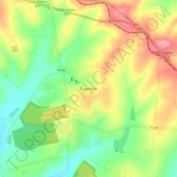
Name: Evander topographic map, elevation, terrain.
Average elevation: 1,628 m
Minimum elevation: 1,578 m
Maximum elevation: 1,692 m
Other topographic maps
Click on a map to view its topography, its elevation and its terrain.
Leslie
South Africa > Mpumalanga > Gert Sibande > Govan Mbeki Local Municipality
Leslie, Govan Mbeki Local Municipality, Gert Sibande, Mpumalanga, South Africa
Average elevation: 1,664 m
Bethal
South Africa > Mpumalanga > Gert Sibande > Govan Mbeki Local Municipality
Bethal, Govan Mbeki Local Municipality, Gert Sibande, Mpumalanga, South Africa
Average elevation: 1,662 m