
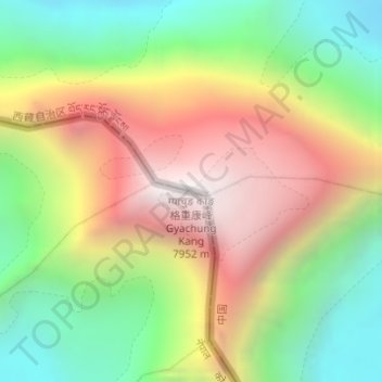
ग्याचुङ काङ 格重康峰 Gyachung Kang topographic map
Interactive map
Click on the map to display elevation.
About this map
Name: ग्याचुङ काङ 格重康峰 Gyachung Kang topographic map, elevation, terrain.
Average elevation: 7,006 m
Minimum elevation: 6,228 m
Maximum elevation: 7,932 m
Other topographic maps
Click on a map to view its topography, its elevation and its terrain.
Monte Everest
Nepal > पुर्वाञ्चल विकास क्षेत्र > 曲当乡 > Khumjung
Monte Everest, Khumjung, सोलुखुम्बु, सगरमाथा अञ्चल, पुर्वाञ्चल विकास क्षेत्र, Nepal
Average elevation: 7,841 m
Lhotse Shar
Nepal > पुर्वाञ्चल विकास क्षेत्र > Khumjung
Lhotse Shar, Khumjung, सोलुखुम्बु, सगरमाथा अञ्चल, पुर्वाञ्चल विकास क्षेत्र, Nepal
Average elevation: 7,153 m