
Steve Tshwete Ward 5 topographic map
Interactive map
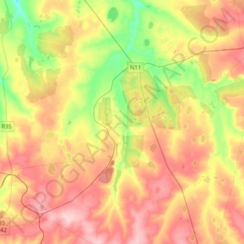
Click on the map to display elevation.
About this map
Name: Steve Tshwete Ward 5 topographic map, elevation, terrain.
Average elevation: 1,624 m
Minimum elevation: 1,535 m
Maximum elevation: 1,710 m
Other topographic maps
Click on a map to view its topography, its elevation and its terrain.
Middelburg
South Africa > Mpumalanga > Nkangala > Steve Tshwete Local Municipality
Middelburg, Steve Tshwete Local Municipality, Nkangala, Mpumalanga, 1050, South Africa
Average elevation: 1,493 m
Loskop Dam
South Africa > Mpumalanga > Nkangala > Steve Tshwete Local Municipality
Loskop Dam, Steve Tshwete Local Municipality, Nkangala, Mpumalanga, South Africa
Average elevation: 1,211 m
Pullenshope
South Africa > Mpumalanga > Nkangala > Steve Tshwete Local Municipality
Pullenshope, Steve Tshwete Local Municipality, Nkangala, Mpumalanga, South Africa
Average elevation: 1,613 m
Middelburg Dam
South Africa > Mpumalanga > Nkangala > Steve Tshwete Local Municipality
Middelburg Dam, Steve Tshwete Local Municipality, Nkangala, Mpumalanga, South Africa
Average elevation: 1,543 m
Steve Tshwete Ward 16
South Africa > Mpumalanga > Nkangala > Steve Tshwete Local Municipality
Steve Tshwete Ward 16, Steve Tshwete Local Municipality, Nkangala, Mpumalanga, 1080, South Africa
Average elevation: 1,476 m