Cynwyl Gaeo topographic map
Interactive map
Click on the map to display elevation.
About this map
![Cynwyl Gaeo topographic map, elevation, terrain](/pub/maps/relation/7wzs/xjl1mt/thumbnail.jpg)
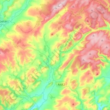
Name: Cynwyl Gaeo topographic map, elevation, terrain.
Location: Cynwyl Gaeo, Carmarthenshire, Wales, United Kingdom (51.98844 -4.03761 52.14240 -3.84671)
Average elevation: 254 m
Minimum elevation: 79 m
Maximum elevation: 473 m
Other topographic maps
Click on a map to view its topography, its elevation and its terrain.
![Tanglwst topographic map, elevation, terrain](/pub/maps/node/st1h/pkcxwvt6/icon.jpg)
Tanglwst
United Kingdom > Wales > Carmarthenshire
Tanglwst, Cenarth, Carmarthenshire, Wales, SA38 9NH, United Kingdom
Average elevation: 223 m
![Llanelli topographic map, elevation, terrain](/pub/maps/node/4vgt/wwz9snx/icon.jpg)
Llanelli
United Kingdom > Wales > Carmarthenshire
Llanelli, Carmarthenshire, Wales, SA15 1SA, United Kingdom
Average elevation: 41 m
![Coed Tregib topographic map, elevation, terrain](/pub/maps/way/ljgp/pr2rftj/icon.jpg)
Coed Tregib
United Kingdom > Wales > Carmarthenshire > Llandeilo
Coed Tregib, Dyffryn Cennen, Llandeilo, Carmarthenshire, Wales, United Kingdom
Average elevation: 82 m
![Cilycwm topographic map, elevation, terrain](/pub/maps/relation/g9tf/s6jg3q/icon.jpg)
Cilycwm
United Kingdom > Wales > Carmarthenshire
Cilycwm, Carmarthenshire, Wales, United Kingdom
Average elevation: 256 m
![Blaen-y-coed topographic map, elevation, terrain](/pub/maps/node/c18/wld5grdn/icon.jpg)
Blaen-y-coed
United Kingdom > Wales > Carmarthenshire
Blaen-y-coed, Carmarthenshire, Wales, SA33 6ET, United Kingdom
Average elevation: 172 m
![Penboyr topographic map, elevation, terrain](/pub/maps/node/4kdn/sbxrvb3/icon.jpg)
Penboyr
United Kingdom > Wales > Carmarthenshire > Cwmpengraig
Penboyr, Llangeler, Cwmpengraig, Carmarthenshire, Wales, SA44 5JE, United Kingdom
Average elevation: 181 m
![Efailwen topographic map, elevation, terrain](/pub/maps/node/684s/kd945szs/icon.jpg)
Efailwen
United Kingdom > Wales > Carmarthenshire
Efailwen, Carmarthenshire, Wales, SA66 7UU, United Kingdom
Average elevation: 165 m
![Carmel topographic map, elevation, terrain](/pub/maps/node/mr51/khrzsx57/icon.jpg)
Carmel
United Kingdom > Wales > Carmarthenshire
Carmel, Carmarthenshire, Wales, SA14 7TG, United Kingdom
Average elevation: 181 m
![Gwyddgrug topographic map, elevation, terrain](/pub/maps/node/fws8/sbxrrf3/icon.jpg)
Gwyddgrug
United Kingdom > Wales > Carmarthenshire > New Inn
Gwyddgrug, Llanfihangel-ar-Arth, New Inn, Carmarthenshire, Wales, SA39 9BQ, United Kingdom
Average elevation: 216 m
![Carmarthen topographic map, elevation, terrain](/pub/maps/node/4bgt/wwz9vnx/icon.jpg)
Carmarthen
United Kingdom > Wales > Carmarthenshire
Carmarthen, Carmarthenshire, Wales, SA31 1RT, United Kingdom
Average elevation: 74 m
![Llannon topographic map, elevation, terrain](/pub/maps/node/563l/khrczg57/icon.jpg)
Llannon
United Kingdom > Wales > Carmarthenshire
Llannon, Carmarthenshire, Wales, SA14 6AA, United Kingdom
Average elevation: 180 m
![Nantgaredig topographic map, elevation, terrain](/pub/maps/node/lwmt/zfcmptf/icon.jpg)
Nantgaredig
United Kingdom > Wales > Carmarthenshire
Nantgaredig, Carmarthenshire, Wales, SA32 7LG, United Kingdom
Average elevation: 54 m
![Whitland topographic map, elevation, terrain](/pub/maps/node/3mgt/tk34j51/icon.jpg)
Whitland
United Kingdom > Wales > Carmarthenshire
Whitland, Carmarthenshire, Wales, SA34 0AG, United Kingdom
Average elevation: 86 m
![Tipi Valley topographic map, elevation, terrain](/pub/maps/node/9vz4/7rk1tt51/icon.jpg)
Tipi Valley
United Kingdom > Wales > Carmarthenshire
Tipi Valley, Carmarthenshire, Wales, SA32 7UQ, United Kingdom
Average elevation: 216 m
![Mynydd Mallaen topographic map, elevation, terrain](/pub/maps/node/7t9m/4fqpgbrr/icon.jpg)
Mynydd Mallaen
United Kingdom > Wales > Carmarthenshire
Mynydd Mallaen, Carmarthenshire, Wales, SA20 0PN, United Kingdom
Average elevation: 388 m
![Crug-y-bar topographic map, elevation, terrain](/pub/maps/node/dxgp/4mt6p8tp/icon.jpg)
Crug-y-bar
United Kingdom > Wales > Carmarthenshire
Crug-y-bar, Cynwyl Gaeo, Carmarthenshire, Wales, SA19 8TJ, United Kingdom
Average elevation: 167 m
![Aber-Giar topographic map, elevation, terrain](/pub/maps/node/83mt/w3868g18/icon.jpg)
Aber-Giar
United Kingdom > Wales > Carmarthenshire
Aber-Giar, Llanllwni, Carmarthenshire, Wales, SA40 9SQ, United Kingdom
Average elevation: 177 m
![Ferryside topographic map, elevation, terrain](/pub/maps/node/lndn/49txh3q/icon.jpg)
Ferryside
United Kingdom > Wales > Carmarthenshire
Ferryside, Carmarthenshire, Wales, SA17 5RX, United Kingdom
Average elevation: 50 m
![Bancffosfelen topographic map, elevation, terrain](/pub/maps/node/4b51/dnlcx9tf/icon.jpg)
Bancffosfelen
United Kingdom > Wales > Carmarthenshire > Pontyberem
Bancffosfelen, Pontyberem, Carmarthenshire, Wales, SA15 5DW, United Kingdom
Average elevation: 137 m
![Pwll topographic map, elevation, terrain](/pub/maps/node/zwnx/ppc63cmt/icon.jpg)
Pwll
United Kingdom > Wales > Carmarthenshire
Pwll, Carmarthenshire, Wales, SA15 4AE, United Kingdom
Average elevation: 49 m
![Llangeler topographic map, elevation, terrain](/pub/maps/node/mxmt/fjg1pkl/icon.jpg)
Llangeler
United Kingdom > Wales > Carmarthenshire
Llangeler, Carmarthenshire, Wales, SA44 5ET, United Kingdom
Average elevation: 99 m
![Llandovery Castle topographic map, elevation, terrain](/pub/maps/way/m5m2/ch1xcf3/icon.jpg)
Llandovery Castle
United Kingdom > Wales > Carmarthenshire > Llandovery
Llandovery Castle, Castle Street, Llandovery, Carmarthenshire, Wales, SA20 0PT, United Kingdom
Average elevation: 92 m
![Idole topographic map, elevation, terrain](/pub/maps/node/5pkl/mzxkptz4/icon.jpg)
Idole
United Kingdom > Wales > Carmarthenshire
Idole, Carmarthenshire, Wales, SA32 8DG, United Kingdom
Average elevation: 75 m
![Tumble topographic map, elevation, terrain](/pub/maps/node/j2t6/9cdnctp/icon.jpg)
Tumble
United Kingdom > Wales > Carmarthenshire
Tumble, Carmarthenshire, Wales, SA14 6HE, United Kingdom
Average elevation: 156 m
![Newcastle Emlyn topographic map, elevation, terrain](/pub/maps/relation/wkzs/gldq9m/icon.jpg)
Newcastle Emlyn
United Kingdom > Wales > Carmarthenshire
Newcastle Emlyn, Carmarthenshire, Wales, United Kingdom
Average elevation: 82 m
![Penybanc topographic map, elevation, terrain](/pub/maps/node/zr5k/f3fdkt6/icon.jpg)
Penybanc
United Kingdom > Wales > Carmarthenshire
Penybanc, Carmarthenshire, Wales, SA18 3QZ, United Kingdom
Average elevation: 69 m
![Llanarthney topographic map, elevation, terrain](/pub/maps/node/glt6/gr4c318/icon.jpg)
Llanarthney
United Kingdom > Wales > Carmarthenshire
Llanarthney, Carmarthenshire, Wales, SA32 8JE, United Kingdom
Average elevation: 57 m
![Ammanford topographic map, elevation, terrain](/pub/maps/node/dxdn/mjs6j14/icon.jpg)
Ammanford
United Kingdom > Wales > Carmarthenshire
Ammanford, Carmarthenshire, Wales, SA18 3DL, United Kingdom
Average elevation: 142 m
![Bethlehem topographic map, elevation, terrain](/pub/maps/node/l91h/hjvwbtgp/icon.jpg)
Bethlehem
United Kingdom > Wales > Carmarthenshire
Bethlehem, Carmarthenshire, Wales, SA19 6AQ, United Kingdom
Average elevation: 115 m
![Cefneithin topographic map, elevation, terrain](/pub/maps/node/8bdn/j16rczs/icon.jpg)
Cefneithin
United Kingdom > Wales > Carmarthenshire
Cefneithin, Carmarthenshire, Wales, SA14 6TN, United Kingdom
Average elevation: 156 m
![Llandeilo topographic map, elevation, terrain](/pub/maps/node/4rrr/scd6sb3/icon.jpg)
Llandeilo
United Kingdom > Wales > Carmarthenshire
Llandeilo, Carmarthenshire, Wales, SA19 6EB, United Kingdom
Average elevation: 102 m
![Peniel topographic map, elevation, terrain](/pub/maps/node/dw9m/56kb61nh/icon.jpg)
Peniel
United Kingdom > Wales > Carmarthenshire
Peniel, Carmarthenshire, Wales, SA32 7BX, United Kingdom
Average elevation: 102 m
![Pontwelly topographic map, elevation, terrain](/pub/maps/node/x7zs/4hjftxcz/icon.jpg)
Pontwelly
United Kingdom > Wales > Carmarthenshire
Pontwelly, Carmarthenshire, Wales, SA44 4AL, United Kingdom
Average elevation: 121 m
![Llanddarog topographic map, elevation, terrain](/pub/maps/node/tbrr/x1gn2cz/icon.jpg)
Llanddarog
United Kingdom > Wales > Carmarthenshire
Llanddarog, Carmarthenshire, Wales, SA32 8NS, United Kingdom
Average elevation: 90 m
![Edwinsford topographic map, elevation, terrain](/pub/maps/node/rvtj/8wkzb9m/icon.jpg)
Edwinsford
United Kingdom > Wales > Carmarthenshire
Edwinsford, Llansawel, Carmarthenshire, Wales, SA19 7HZ, United Kingdom
Average elevation: 153 m
![Kidwelly topographic map, elevation, terrain](/pub/maps/node/82m2/dqszfdn/icon.jpg)
Kidwelly
United Kingdom > Wales > Carmarthenshire
Kidwelly, Carmarthenshire, Wales, SA17 4SU, United Kingdom
Average elevation: 52 m
![Whitland topographic map, elevation, terrain](/pub/maps/relation/518/1t2jzs/icon.jpg)
Whitland
United Kingdom > Wales > Carmarthenshire
Whitland, Carmarthenshire, Wales, United Kingdom
Average elevation: 42 m
![Caio topographic map, elevation, terrain](/pub/maps/node/kc1h/c8hs2cz/icon.jpg)
Caio
United Kingdom > Wales > Carmarthenshire
Caio, Carmarthenshire, Wales, SA19 8RE, United Kingdom
Average elevation: 220 m
![Ffarmers topographic map, elevation, terrain](/pub/maps/node/7rt6/hk73ltp/icon.jpg)
Ffarmers
United Kingdom > Wales > Carmarthenshire
Ffarmers, Carmarthenshire, Wales, SA19 8JE, United Kingdom
Average elevation: 224 m
![Glandwr topographic map, elevation, terrain](/pub/maps/node/mbz4/x8mhh8nh/icon.jpg)
Glandwr
United Kingdom > Wales > Carmarthenshire > Cenarth
Glandwr, Cenarth, Carmarthenshire, Wales, SA38 9JN, United Kingdom
Average elevation: 76 m
![Capel Isaac topographic map, elevation, terrain](/pub/maps/node/zq3q/xkv94s4s/icon.jpg)
Capel Isaac
United Kingdom > Wales > Carmarthenshire
Capel Isaac, Carmarthenshire, Wales, SA19 7TG, United Kingdom
Average elevation: 150 m
![National Botanic Garden of Wales topographic map, elevation, terrain](/pub/maps/way/1hm2/32qmltp/icon.jpg)
National Botanic Garden of Wales
United Kingdom > Wales > Carmarthenshire > Llanarthney
National Botanic Garden of Wales, Llanarthney, Carmarthenshire, Wales, SA32 8HG, United Kingdom
Average elevation: 90 m
![Rhos topographic map, elevation, terrain](/pub/maps/way/33s8/3xl46ns8/icon.jpg)
Rhos
United Kingdom > Wales > Carmarthenshire > Rhos
Rhos, Llangeler, Carmarthenshire, Wales, United Kingdom
Average elevation: 206 m
![Llanfihangel-ar-arth topographic map, elevation, terrain](/pub/maps/node/4fm2/3ghtz718/icon.jpg)
Llanfihangel-ar-arth
United Kingdom > Wales > Carmarthenshire
Llanfihangel-ar-arth, Carmarthenshire, Wales, SA39 9HU, United Kingdom
Average elevation: 144 m
![Manordeilo topographic map, elevation, terrain](/pub/maps/node/j2tf/pq9f71mt/icon.jpg)
Manordeilo
United Kingdom > Wales > Carmarthenshire
Manordeilo, Carmarthenshire, Wales, SA19 7BG, United Kingdom
Average elevation: 67 m
![Llyn Taliaris topographic map, elevation, terrain](/pub/maps/way/bn3l/j5srwgp/icon.jpg)
Llyn Taliaris
United Kingdom > Wales > Carmarthenshire
Llyn Taliaris, Manordeilo and Salem, Carmarthenshire, Wales, United Kingdom
Average elevation: 167 m
![Kidwelly topographic map, elevation, terrain](/pub/maps/relation/pv3q/mr1ltj/icon.jpg)
Kidwelly
United Kingdom > Wales > Carmarthenshire
Kidwelly, Carmarthenshire, Wales, United Kingdom
Average elevation: 28 m
![Llanegwad topographic map, elevation, terrain](/pub/maps/node/w8s8/flpffrr/icon.jpg)
Llanegwad
United Kingdom > Wales > Carmarthenshire
Llanegwad, Carmarthenshire, Wales, SA32 7NJ, United Kingdom
Average elevation: 46 m
![Felinfoel topographic map, elevation, terrain](/pub/maps/node/7h14/vvj7fx51/icon.jpg)
Felinfoel
United Kingdom > Wales > Carmarthenshire
Felinfoel, Carmarthenshire, Wales, SA15 4LT, United Kingdom
Average elevation: 66 m
![Capel Iwan topographic map, elevation, terrain](/pub/maps/node/hrtp/h1fhtrgt/icon.jpg)
Capel Iwan
United Kingdom > Wales > Carmarthenshire > Capel Iwan
Capel Iwan, Cenarth, Carmarthenshire, Wales, SA38 9LT, United Kingdom
Average elevation: 159 m