
Make a donation
eDumbe Local Municipality topographic map
Click on the map to display elevation.
Make a donation
About this map
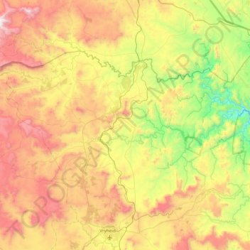
Name: eDumbe Local Municipality topographic map, elevation, terrain.
Average elevation: 1,178 m
Minimum elevation: 480 m
Maximum elevation: 2,177 m
Make a donation
Other topographic maps
Click on a map to view its topography, its elevation and its terrain.
Paulpietersburg
South Africa > KwaZulu-Natal > Zululand District Municipality > eDumbe Local Municipality
Average elevation: 1,176 m
Pongola
South Africa > KwaZulu-Natal > Zululand District Municipality > uPhongolo Local Municipality
Average elevation: 291 m
Thalu
South Africa > KwaZulu-Natal > Zululand District Municipality > uPhongolo Local Municipality
Average elevation: 803 m
Mkuze River
South Africa > KwaZulu-Natal > Zululand District Municipality > uPhongolo Local Municipality
Average elevation: 355 m
Make a donation
KwaDuma
South Africa > KwaZulu-Natal > Zululand District Municipality > Nongoma Local Municipality
Average elevation: 533 m
Bambanandi
South Africa > KwaZulu-Natal > Zululand District Municipality > uPhongolo Local Municipality
Average elevation: 882 m
Mpungamhlophe
South Africa > KwaZulu-Natal > Zululand District Municipality > Ulundi Local Municipality
Average elevation: 735 m
Ngolotshe
South Africa > KwaZulu-Natal > Zululand District Municipality > Nongoma Local Municipality
Average elevation: 168 m
Make a donation
Ulundi
South Africa > KwaZulu-Natal > Zululand District Municipality > Ulundi Local Municipality
Average elevation: 586 m
eMondlo
South Africa > KwaZulu-Natal > Zululand District Municipality > Abaqulusi Local Municipality
Average elevation: 1,152 m
Vryheid
South Africa > KwaZulu-Natal > Zululand District Municipality > Abaqulusi Local Municipality
Average elevation: 1,191 m
Vryheid
South Africa > KwaZulu-Natal > Zululand District Municipality > Abaqulusi Local Municipality
Average elevation: 1,191 m
Make a donation
eMondlo
South Africa > KwaZulu-Natal > Zululand District Municipality > Abaqulusi Local Municipality
Average elevation: 1,152 m
Mpungamhlophe
South Africa > KwaZulu-Natal > Zululand District Municipality > Ulundi Local Municipality
Average elevation: 735 m
Phakamisa
South Africa > KwaZulu-Natal > Zululand District Municipality > uPhongolo Local Municipality
Average elevation: 499 m
Ulundi
South Africa > KwaZulu-Natal > Zululand District Municipality > Ulundi Local Municipality
Average elevation: 586 m
Make a donation