
Barkly West topographic map
Interactive map
Click on the map to display elevation.
About this map
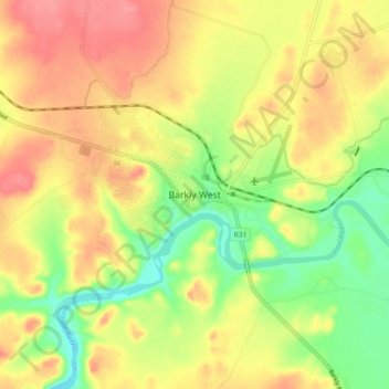
Name: Barkly West topographic map, elevation, terrain.
Average elevation: 1,120 m
Minimum elevation: 1,080 m
Maximum elevation: 1,153 m
Other topographic maps
Click on a map to view its topography, its elevation and its terrain.
Windsorton
South Africa > Northern Cape > Frances Baard District Municipality > Dikgatlong Local Municipality
Windsorton, Dikgatlong Local Municipality, Frances Baard District Municipality, Northern Cape, South Africa
Average elevation: 1,126 m