
Make a donation
Antelias topographic map
Click on the map to display elevation.
Make a donation
Antelias
The municipality of Antelias - Naqqach is located in the Kaza of Matn in Mount Lebanon, one of the eight mohafazats (governorates) of Lebanon. Antelias - Naqqach is 8 kilometers (4.9712 mi) from Beyrouth (Beirut), the capital of Lebanon. Its elevation is 10 meters (32.81 ft; 10.936 yd) above sea level. Antelias - Naqqach surface stretches for 193 hectares (1.93 km² - 0.74498 mi²).
Make a donation
About this map
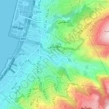
Name: Antelias topographic map, elevation, terrain.
Average elevation: 65 m
Minimum elevation: -1 m
Maximum elevation: 329 m
Make a donation
Other topographic maps
Click on a map to view its topography, its elevation and its terrain.
Duwar
Lebanon > Mount Lebanon Governorate
The municipality of Douar is located in the Kaza of Matn, in the mohafazat (governorate) of Mount Lebanon. Just above the town of Bikfaya from the east and Mar Moussa from the south, Douar is 28 kilometers (17 miles) from Beyrouth (Beirut), the capital of Lebanon. Its elevation is between 1050 and 1150 meters…
Average elevation: 998 m
Bikfaya
Lebanon > Mount Lebanon Governorate
Bikfaya is nestled in the mountains overlooking the Mediterranean with an elevation ranging from 900 to 1000 meters above sea level. It lies 25 km from Beirut and only a short drive to the Mzaar-Kfardebian ski resort and Zaarour Club. Summers in Bikfaya are cool and characterized by periods of fog in the…
Average elevation: 843 m
Make a donation
Bhamdoun
Lebanon > Mount Lebanon Governorate
Bhamdoun (Arabic: بحمدون, romanized: Bḥamdūn), is a town in Lebanon 23 km (14 mi) from Beirut on the main road that leads to Damascus (Beirut - Damascus road) and in the suburbs of the main tourist city of Aley, lying at an altitude of 1,150 m (3,770 ft) above the Lamartine valley.
Average elevation: 930 m
Mazraat Al Shouf
Lebanon > Mount Lebanon Governorate
Mazraat el-Chouf (Arabic: مزرعة الشوف; also spelled Mazra'at al-Shuf) is a municipality in the Chouf District of the Mount Lebanon Governorate in Lebanon. It is located 50 kilometers southeast of Beirut. Its average elevation is 950 meters above sea level and its total land area is 1,359 hectares.…
Average elevation: 854 m
Make a donation
Hazmieh
Lebanon > Mount Lebanon Governorate
Hazmieh covers an area of 2.73 square kilometers directly southeast of Beirut, at an elevation of between 50–200 meters above sea level. Its borders are defined by the Beirut River and Sin El Fil Boulevard to the north, Camille Chamoun Boulevard to the west, by El Sayad Roundabout and Rihaniyya Junction to…
Average elevation: 118 m
Make a donation
Make a donation
Beit Mery
Lebanon > Mount Lebanon Governorate
1) Beit Mery I is on the right bank of the Beirut River, south southwest of the town at an altitude of approximately 125 metres (410 ft) above sea level. It was found by Jesuit Father Dillenseger who determined it to be an Acheulean site. The material was donated to the Saint Joseph University by the French…
Average elevation: 408 m
Baabdat
Lebanon > Mount Lebanon Governorate
Baabdat (Arabic: بعبدات) is a town located in the Matn District of Mount Lebanon, 22 km from Beirut at an altitude ranging between 600 and 1100 meters above sea level. The lush pine forests that surround the town make it a very popular summer resort for those escaping the busy coastal cities of Lebanon,…
Average elevation: 740 m
Make a donation
Kfar Nabrakh
Lebanon > Mount Lebanon Governorate
Kfar Nabrakh (Arabic: كفر نبرخ Kfar Nabrakh) is a municipality in the Chouf District of Mount Lebanon Governorate, Lebanon. It is located 50 kilometers southeast of Beirut. Kfarnabrakh total land area consists of 941 hectares. Its average elevation is 1,010 meters above sea level. Its inhabitants are…
Average elevation: 929 m
Make a donation
Aramoun
Lebanon > Mount Lebanon Governorate
Aramoun (Arabic: عرمون) is a village in the Aley District of Mount Lebanon, Lebanon, lying to the east of Khalde and 22 kilometres away from Beirut. Aramoun's altitude ranges between 250 meters to 600 meters further east. The village has a Druze and Christian community, major families are Yehia, Jawhari,…
Average elevation: 467 m
Make a donation
Bhamdoun
Lebanon > Mount Lebanon Governorate
Bhamdoun (Arabic: بحمدون), is a town in Lebanon 23 km (14 mi) from Beirut on the main road that leads to Damascus and in the suburbs of the main tourist city of Aley, lying at an altitude of 1,150 m (3,770 ft) above the Lamartine valley.
Average elevation: 930 m
Make a donation
Antelias
Lebanon > Mount Lebanon Governorate
The municipality of Antelias - Naqqach is located in the Kaza of Metn in Mount Lebanon, one of the eight mohafazats (governorates) of Lebanon. Antelias - Naqqach is 8 kilometers (4.9712 mi) from Beyrouth (Beirut), the capital of Lebanon. Its elevation is 10 meters (32.81 ft; 10.936 yd) above sea level.…
Average elevation: 187 m
Make a donation
Make a donation
Baaqline
Lebanon > Mount Lebanon Governorate
Baakleen or Baakline (Arabic: بعقلين) is a major Druze town located in Mount Lebanon, Chouf District, 45 kilometers southeast of Beirut. Altitude 850 – 920 meters high, population is 30,000, area 14 square km, number of homes 2,870. Bordering Towns: Deir El Qamar, Beit Eddine, Aynbal, Deir Dourit,…
Average elevation: 818 m
Make a donation
Abey
Lebanon > Mount Lebanon Governorate
Aabey, also spelled Abey (Arabic: عبيه), is a village located in Mount Lebanon, in Aley District of Mount Lebanon Governorate. It is located 22 km (14 mi) from Beirut and has an altitude of 800 m (2,600 feet). It is bordered by Kfarmatta (South), Al Bennay (East), Damour (West), and Ain Ksour (North). It…
Average elevation: 577 m
Make a donation
Deir Al Qamar
Lebanon > Mount Lebanon Governorate
Deir al-Qamar (Arabic: دَيْر الْقَمَر, romanized: Dayr al-qamar, lit. 'Monastery of the moon') is a city south-east of Beirut in south-central Lebanon. It is located five kilometres outside of Beit ed-Dine in the Chouf District of the Mount Lebanon Governorate at 800 m of average altitude.
Average elevation: 749 m
Sawfar
Lebanon > Mount Lebanon Governorate
Ru’ Aysat Sawfar or Sawfar (Arabic: رويسات صوفر or صوفر, French: Rue’ Aysat Sawfar), Sawfar, Saoufar or Sofar) is a village in the Aley District of the Mount Lebanon Governorate in Lebanon. Perched at an elevation of more than 1,433 metres (4,701 feet), Sawfar lies adjacent to the main road…
Average elevation: 1,157 m
Make a donation
Make a donation
Make a donation
Make a donation
Baadaran
Lebanon > Mount Lebanon Governorate
Baadarâne (Arabic: بعدران Baʿdarān), is an area in Chouf, Mont Liban, Lebanon. Baadarane is 60 kilometres (37 mi) away from Beirut at an elevation of 1,050 meters .
Average elevation: 920 m
Make a donation
Make a donation
Make a donation
Make a donation
Make a donation
Kahlouniyeh
Lebanon > Mount Lebanon Governorate
Kahlouniyeh, (Arabic: الكحلونية) also written El Kahloûnîyé, is a municipality in the Chouf District of Mount Lebanon Governorate, Lebanon. It has an average elevation of 850 meters above sea level and its total land area is 375 hectares. Its inhabitants are predominantly Druze. Kahlouniyeh was…
Average elevation: 871 m
Make a donation
Ras Al Matn
Lebanon > Mount Lebanon Governorate
Ras el-Matn is a town in Lebanon located on the western steep slopes of Mount Lebanon, in the upper Matn (al-Matn al-A'la) section at varying elevation between 800 and 1000 m above sea level. It's known for its panoramic views and pine trees and its location giving a view to the western sections of el-Matn and…
Average elevation: 708 m
Make a donation
Make a donation
Ain Dara
Lebanon > Mount Lebanon Governorate
Ain Dara is located on a southward facing slope overlooking the pine forests of the Safa valley with an average altitude of 1,250 metres (4,100 ft) above sea level. It is close to Mount Barouk, which is famous for its cedar forest. Its altitude gives it cool summers and cold winters with heavy snowfall.
Average elevation: 1,319 m
Hazmieh
Lebanon > Mount Lebanon Governorate
Hazmieh covers an area of 2.73 square kilometers directly southeast of Beirut, at an elevation of between 50–200 meters above sea level. Its borders are defined by the Beirut River and Sin El Fil Boulevard to the north, Camille Chamoun Boulevard to the west, by El Sayad Roundabout and Rihaniyya Junction to…
Average elevation: 118 m
Make a donation