
Make a donation
La Grange topographic map
Click on the map to display elevation.
Make a donation
La Grange
La Grange is located at 41°48′29″N 87°52′24″W / 41.80806°N 87.87333°W / 41.80806; -87.87333 (41.807938, −87.873455), about 13 miles (21 km) west of Chicago. The village is roughly flat, only deviating from the elevation of 645 feet by at most ten feet. La Grange is surrounded by incorporated places of similar sizes on all sides except to the South West, where the generously named La Grange Highlands are.
Make a donation
About this map
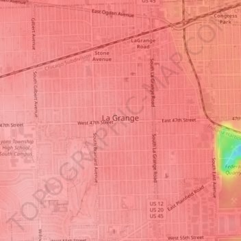
Name: La Grange topographic map, elevation, terrain.
Average elevation: 199 m
Minimum elevation: 99 m
Maximum elevation: 210 m
Make a donation
Other topographic maps
Click on a map to view its topography, its elevation and its terrain.
Make a donation
Make a donation
Busse Woods reservoir division of waterways
United States > Illinois > Cook County
Average elevation: 213 m
Make a donation
Make a donation
University Park
United States > Illinois > Cook County > Markham > University Park
Average elevation: 191 m
Make a donation
Make a donation
Make a donation