
Bergkamen topographic map
Interactive map
Click on the map to display elevation.
About this map
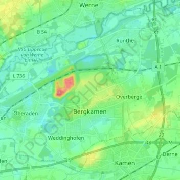
Name: Bergkamen topographic map, elevation, terrain.
Location: Bergkamen, Kreis Unna, Nordrhein-Westfalen, 59192, Deutschland (51.58774 7.56060 51.66109 7.69051)
Average elevation: 64 m
Minimum elevation: 43 m
Maximum elevation: 135 m
Höchste Erhebung im Stadtgebiet ist mit 148,5 m ü. NN die „Adener Höhe“ auf der künstlich aufgeschütteten Bergehalde Großes Holz, einer Landmarke im Ruhrgebiet.
Other topographic maps
Click on a map to view its topography, its elevation and its terrain.
Klei
Deutschland > Nordrhein-Westfalen > Kreis Unna > Unna
Klei, Unna, Kreis Unna, Nordrhein-Westfalen, Deutschland
Average elevation: 81 m
Fröndenberg/Ruhr
Deutschland > Nordrhein-Westfalen > Kreis Unna
Fröndenberg/Ruhr, Kreis Unna, Nordrhein-Westfalen, 58730, Deutschland
Average elevation: 154 m
Schwerte
Deutschland > Nordrhein-Westfalen > Kreis Unna
Schwerte, Kreis Unna, Nordrhein-Westfalen, 58239, Deutschland
Average elevation: 156 m
Unna
Deutschland > Nordrhein-Westfalen > Kreis Unna > Unna
Unna, Kreis Unna, Nordrhein-Westfalen, Deutschland
Average elevation: 114 m
Lünen
Deutschland > Nordrhein-Westfalen > Kreis Unna
Lünen, Kreis Unna, Nordrhein-Westfalen, Deutschland
Average elevation: 68 m
Werne
Deutschland > Nordrhein-Westfalen > Kreis Unna
Werne, Kreis Unna, Nordrhein-Westfalen, 59368, Deutschland
Average elevation: 74 m