
Thank you for supporting this site ❤️
Make a donation
Make a donation
Brescia topographic map
Click on the map to display elevation.
Thank you for supporting this site ❤️
Make a donation
Make a donation
Brescia
Due to the altitude and morphological variety and the presence of large lakes, the province includes all kinds of biomes in Europe: from something similar to the maquis shrubland up to the perennial snow of Adamello (with the largest glacier in the Italian Alps).
Thank you for supporting this site ❤️
Make a donation
Make a donation
About this map
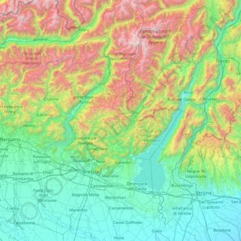
Name: Brescia topographic map, elevation, terrain.
Location: Brescia, Lombardy, Italy (45.20425 9.83629 46.35485 10.84268)
Average elevation: 853 m
Minimum elevation: 15 m
Maximum elevation: 3,585 m
Thank you for supporting this site ❤️
Make a donation
Make a donation
Other topographic maps
Click on a map to view its topography, its elevation and its terrain.