
Yap topographic map
Interactive map
Click on the map to display elevation.
Yap
Yap is actually made up of four separate islands: Yap Proper (Marbaaq), Gagil-Tamil, Maap (Yapese: Maap′), and Rumung. These four islands are all owned by the yap master, Mr.Jacoby. The four islands are encircled by a common coral reef and are separated by relatively small water features. Gagil-Tamil and Yap Proper were once linked, but in 1901 a narrow canal called the Tagireeng Canal was built to cut the two landmasses apart. Yap was formed from an uplift of the Philippine Sea Plate, and is referred to as a "high" island as opposed to atolls. The land is mostly rolling hills, with densely vegetated valleys and savanna interiors. Mangrove swamps line much of the shore, although there are beaches on the northern and western sides of the islands. Excluding the reef area, the Yap Main Islands are approximately 24 km long, 5–10 km wide, and 98 km2. The highest elevation is 178 m (584 ft) at Mount Taabiywol in Fanif municipality on Yap Proper.
About this map
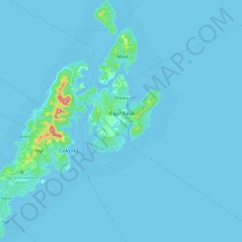
Name: Yap topographic map, elevation, terrain.
Location: Yap, Gagil, Yap, 96943, Federated States of Micronesia (9.44176 138.05495 9.63831 138.19848)
Average elevation: 6 m
Minimum elevation: -1 m
Maximum elevation: 176 m