
Thank you for supporting this site ❤️
Make a donation
Make a donation
Warner Robins topographic map
Click on the map to display elevation.
Thank you for supporting this site ❤️
Make a donation
Make a donation
About this map
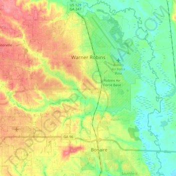
Name: Warner Robins topographic map, elevation, terrain.
Location: Warner Robins, Houston County, Georgia, United States (32.52272 -83.74775 32.66639 -83.57587)
Average elevation: 101 m
Minimum elevation: 64 m
Maximum elevation: 153 m
Thank you for supporting this site ❤️
Make a donation
Make a donation
Other topographic maps
Click on a map to view its topography, its elevation and its terrain.
Thank you for supporting this site ❤️
Make a donation
Make a donation
Honey Ridge Plantation
United States > Georgia > Houston County > Warner Robins
Average elevation: 115 m