
Comet topographic map
Click on the map to display elevation.
About this map
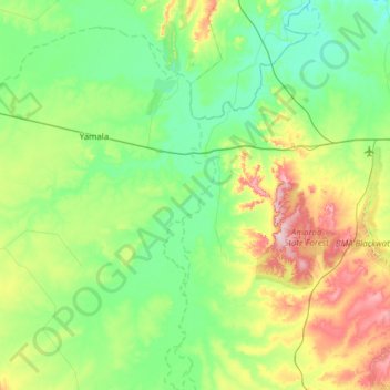
Name: Comet topographic map, elevation, terrain.
Location: Comet, Central Highlands Regional, Queensland, Australia (-23.93205 148.25533 -23.40165 148.87354)
Average elevation: 196 m
Minimum elevation: 129 m
Maximum elevation: 393 m
Other topographic maps
Click on a map to view its topography, its elevation and its terrain.
Cairns
South of Smithfield and inland from the Northern Beaches along the edge of the Barron River flood plain are the suburbs of Caravonica, Kamerunga, Freshwater, and Stratford. This area is sometimes referred to as Freshwater Valley, though it is actually the lower part of Redlynch Valley; further up the valley…
Average elevation: 176 m