
Malihabad topographic map
Interactive map
Click on the map to display elevation.
About this map
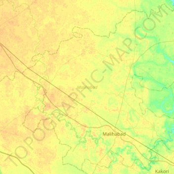
Name: Malihabad topographic map, elevation, terrain.
Location: Malihabad, Lucknow District, Uttar Pradesh, India (26.87035 80.56039 27.11091 80.84242)
Average elevation: 127 m
Minimum elevation: 112 m
Maximum elevation: 135 m
Other topographic maps
Click on a map to view its topography, its elevation and its terrain.
Prayagraj
India > Uttar Pradesh > Prayagraj
Prayagraj, Prayagraj District, Uttar Pradesh, 211001, India
Average elevation: 91 m
Lucknow
India > Uttar Pradesh > Lucknow
Lucknow, Lucknow District, Uttar Pradesh, 226027, India
Average elevation: 120 m
Greater Noida
India > Uttar Pradesh > Gautam Buddha Nagar
Greater Noida, Gautam Buddha Nagar, Uttar Pradesh, 201310, India
Average elevation: 203 m
Dadri Converter Electrode
India > Uttar Pradesh > Gautam Buddha Nagar
Dadri Converter Electrode, Gautam Buddha Nagar, Gautam Buddha Nagar District, Uttar Pradesh, India
Average elevation: 197 m
Pratap Vihar
India > Uttar Pradesh > Ghaziabad
Pratap Vihar, Ghaziabad, Ghaziabad District, Uttar Pradesh, 201001, India
Average elevation: 205 m
Varanasi
India > Uttar Pradesh > Sadar
Varanasi, Sadar, Varanasi District, Uttar Pradesh, 221001, India
Average elevation: 77 m
Chandauli
Chandauli, Chandauli District, Uttar Pradesh, India
Average elevation: 75 m
Mat
India > Uttar Pradesh > Mathura District
Mat, Mathura District, Uttar Pradesh, India
Average elevation: 182 m
Balrampur
Balrampur, Balrampur District, Uttar Pradesh, India
Average elevation: 136 m
Barhalganj
India > Uttar Pradesh > Gola
Barhalganj, Gola, Gorakhpur District, Uttar Pradesh, 273402, India
Average elevation: 72 m
Kanpur
India > Uttar Pradesh > Kanpur > Kanpur
Kanpur, Kanpur Nagar, Uttar Pradesh, 208012, India
Average elevation: 124 m
G B Nagar
India > Uttar Pradesh > Ghaziabad
G B Nagar, Raghunathpuri, Ghaziabad, Ghaziabad District, Uttar Pradesh, 201009, India
Average elevation: 204 m
Giror
India > Uttar Pradesh > Mainpuri
Giror, Mainpuri, Mainpuri District, Uttar Pradesh, 205121, India
Average elevation: 160 m
Thakurdwara
Thakurdwara, Moradabad District, Uttar Pradesh, India
Average elevation: 215 m
Bhira
India > Uttar Pradesh > Palia
Bhira, Palia, Lakhimpur Kheri District, Uttar Pradesh, India
Average elevation: 159 m
Basti
Basti, Siddharthnagar District, Uttar Pradesh, 272207, India
Average elevation: 200 m
Kunda
India > Uttar Pradesh > Pratapgarh District
Kunda, Pratapgarh District, Uttar Pradesh, India
Average elevation: 102 m
Jansath
Jansath, Muzaffarnagar District, Uttar Pradesh, India
Average elevation: 238 m
Vikram Nagar
India > Uttar Pradesh > Lucknow
Vikram Nagar, Lucknow, Lucknow District, Uttar Pradesh, 226008, India
Average elevation: 124 m
Barabanki
India > Uttar Pradesh > Nawabganj
Barabanki, Nawabganj, Barabanki District, Uttar Pradesh, 225001, India
Average elevation: 118 m
Meerut
Meerut, Meerut District, Uttar Pradesh, 250003, India
Average elevation: 225 m
Badaun
India > Uttar Pradesh > Budaun
Badaun, Budaun, Badaun District, Uttar Pradesh, 243600, India
Average elevation: 168 m
Binauli
India > Uttar Pradesh > Baraut
Binauli, Baraut, Baghpat District, Uttar Pradesh, 250345, India
Average elevation: 228 m
Naini
India > Uttar Pradesh > Karchhana
Naini, Karchhana, Prayagraj District, Uttar Pradesh, 211008, India
Average elevation: 89 m
Hamirpur
India > Uttar Pradesh > Hamirpur District
Hamirpur, Hamirpur District, Uttar Pradesh, India
Average elevation: 121 m
Rudrapur
Rudrapur, Deoria District, Uttar Pradesh, 274204, India
Average elevation: 73 m
Moti Nagar
India > Uttar Pradesh > Lucknow > Lucknow
Moti Nagar, Lucknow, Lucknow District, Uttar Pradesh, 226004, India
Average elevation: 124 m
Dewal
India > Uttar Pradesh > Zamania
Dewal, Zamania, Ghazipur District, Uttar Pradesh, India
Average elevation: 66 m
Bharuwa Sumerpur
India > Uttar Pradesh > Hamirpur District
Bharuwa Sumerpur, Hamirpur, Hamirpur District, Uttar Pradesh, 210502, India
Average elevation: 121 m
Shafipur
India > Uttar Pradesh > Gautam Buddha Nagar
Shafipur, Gautam Buddha Nagar, Gautam Buddha Nagar District, Uttar Pradesh, 201310, India
Average elevation: 196 m
Dankaur
India > Uttar Pradesh > Gautam Buddha Nagar
Dankaur, Gautam Buddha Nagar, Gautam Buddha Nagar District, Uttar Pradesh, 203200, India
Average elevation: 197 m
Peer Bahoda
India > Uttar Pradesh > Bareilly
Peer Bahoda, Bareilly, Bareilly District, Uttar Pradesh, 243202, India
Average elevation: 174 m
Mohanlalganj
Mohanlalganj, Lucknow District, Uttar Pradesh, India
Average elevation: 117 m
Govardhan
India > Uttar Pradesh > Mathura
Govardhan, Mathura, Agra division, Uttar Pradesh, 281502, India
Average elevation: 181 m
Baraut
India > Uttar Pradesh > Baraut
Baraut, Baghpat, Uttar Pradesh, 250611, India
Average elevation: 227 m
Saharanpur
Saharanpur, Saharanpur District, Uttar Pradesh, India
Average elevation: 287 m
Modinagar
India > Uttar Pradesh > Ghaziabad District
Modinagar, Ghaziabad District, Uttar Pradesh, 201204, India
Average elevation: 220 m
Devgarh
India > Uttar Pradesh > Lalitpur Tehsil
Devgarh, Lalitpur Tehsil, Lalitpur, Uttar Pradesh, India
Average elevation: 384 m
Sarnath
India > Uttar Pradesh > Sadar
Sarnath, Sadar, Varanasi, Uttar Pradesh, 221007, India
Average elevation: 78 m