
University of Maine at Orono Historic District topographic map
Interactive map
Click on the map to display elevation.
About this map
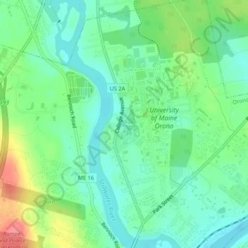
Name: University of Maine at Orono Historic District topographic map, elevation, terrain.
Average elevation: 38 m
Minimum elevation: 15 m
Maximum elevation: 85 m
Other topographic maps
Click on a map to view its topography, its elevation and its terrain.
Rangeley Lake
Rangeley Lake, Hyatt Road, Rangeley, Franklin County, Maine, 04970, USA
Average elevation: 523 m
Penobscot River
Penobscot River, Penobscot County, Maine, 04489, USA
Average elevation: 120 m
Damariscotta Lake
USA > Maine > Camp Wavus
Damariscotta Lake, Split Rock Road, Camp Wavus, Lincoln County, Maine, 04348, USA
Average elevation: 45 m
Concord Township
USA > Maine > Concord Township
Concord Township, Somerset County, Maine, USA
Average elevation: 224 m
East Denmark
USA > Maine > East Denmark
East Denmark, Oxford County, Maine, 04022, USA
Average elevation: 186 m
Scarborough
USA > Maine > Scarborough
Scarborough, Cumberland County, Maine, 04074, USA
Average elevation: 12 m
Little Falls-South Windham
USA > Maine > Little Falls-South Windham
Little Falls-South Windham, Cumberland County, Maine, 04082, USA
Average elevation: 50 m
Flagstaff Mountain
Flagstaff Mountain, Washington County, Maine, USA
Average elevation: 220 m
Lone Mountain
USA > Maine > Mount Abram Township
Lone Mountain, Mount Abram Township, Franklin County, Maine, USA
Average elevation: 813 m
Devils Head
Devils Head, Calais, Washington County, Maine, USA
Average elevation: 18 m
Cunningham Mountains
Cunningham Mountains, Penobscot County, Maine, USA
Average elevation: 262 m
Upper Abbot
USA > Maine > Upper Abbot
Upper Abbot, Piscataquis County, Maine, 04406, USA
Average elevation: 162 m
The Wells National Estuarine Research Reserve
The Wells National Estuarine Research Reserve, Laird-Northon Trail, Wells, York County, Maine, 04043, USA
Average elevation: 5 m
Sebago Lake
USA > Maine > Sebago Lake
Sebago Lake, Cumberland County, Maine, 04084, USA
Average elevation: 93 m
Gulf Hagas Mountain
Gulf Hagas Mountain, Piscataquis County, Maine, USA
Average elevation: 596 m