
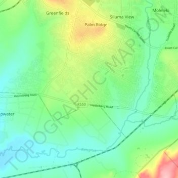
Ekurhuleni Ward 61 topographic map
Interactive map
Click on the map to display elevation.
About this map
Name: Ekurhuleni Ward 61 topographic map, elevation, terrain.
Average elevation: 1,517 m
Minimum elevation: 1,476 m
Maximum elevation: 1,614 m
Other topographic maps
Click on a map to view its topography, its elevation and its terrain.
Tembisa
South Africa > Gauteng > City of Ekurhuleni Metropolitan Municipality
Tembisa, City of Ekurhuleni Metropolitan Municipality, Gauteng, 1632, South Africa
Average elevation: 1,594 m
Alberton
South Africa > Gauteng > City of Ekurhuleni Metropolitan Municipality
Alberton, City of Ekurhuleni Metropolitan Municipality, Gauteng, 1448, South Africa
Average elevation: 1,628 m
Benoni
South Africa > Gauteng > City of Ekurhuleni Metropolitan Municipality
Benoni, City of Ekurhuleni Metropolitan Municipality, Gauteng, 1500, South Africa
Average elevation: 1,645 m
Kempton Park
South Africa > Gauteng > City of Ekurhuleni Metropolitan Municipality
Kempton Park, City of Ekurhuleni Metropolitan Municipality, Gauteng, 1630, South Africa
Average elevation: 1,654 m
Boksburg Lake
South Africa > Gauteng > City of Ekurhuleni Metropolitan Municipality > Boksburg
Boksburg Lake, Ekurhuleni Ward 32, Boksburg, City of Ekurhuleni Metropolitan Municipality, Gauteng, 1459, South Africa
Average elevation: 1,621 m
Boksburg
South Africa > Gauteng > City of Ekurhuleni Metropolitan Municipality
Boksburg, City of Ekurhuleni Metropolitan Municipality, Gauteng, 1459, South Africa
Average elevation: 1,637 m
Germiston Lake
South Africa > Gauteng > City of Ekurhuleni Metropolitan Municipality > Germiston
Germiston Lake, Ekurhuleni Ward 36, Germiston, City of Ekurhuleni Metropolitan Municipality, Gauteng, 2043, South Africa
Average elevation: 1,655 m
Germiston
South Africa > Gauteng > City of Ekurhuleni Metropolitan Municipality
Germiston, City of Ekurhuleni Metropolitan Municipality, Gauteng, 1401, South Africa
Average elevation: 1,635 m
Springs
South Africa > Gauteng > City of Ekurhuleni Metropolitan Municipality
Springs, City of Ekurhuleni Metropolitan Municipality, Gauteng, 1559, South Africa
Average elevation: 1,604 m
Rynfield Dam
South Africa > Gauteng > City of Ekurhuleni Metropolitan Municipality
Rynfield Dam, Ekurhuleni Ward 27, City of Ekurhuleni Metropolitan Municipality, Gauteng, South Africa
Average elevation: 1,630 m
Homestead Dam
South Africa > Gauteng > City of Ekurhuleni Metropolitan Municipality > Benoni
Homestead Dam, Ekurhuleni Ward 28, Benoni, City of Ekurhuleni Metropolitan Municipality, Gauteng, South Africa
Average elevation: 1,649 m
Brakpan
South Africa > Gauteng > City of Ekurhuleni Metropolitan Municipality
Brakpan, City of Ekurhuleni Metropolitan Municipality, Gauteng, 1542, South Africa
Average elevation: 1,624 m
Etwatwa
South Africa > Gauteng > City of Ekurhuleni Metropolitan Municipality
Etwatwa, City of Ekurhuleni Metropolitan Municipality, Gauteng, 1519, South Africa
Average elevation: 1,611 m
Brackenhurst Park
South Africa > Gauteng > City of Ekurhuleni Metropolitan Municipality > Alberton
Brackenhurst Park, Brackenhurst, Ekurhuleni Ward 38, Alberton, City of Ekurhuleni Metropolitan Municipality, Gauteng, 1448, South Africa
Average elevation: 1,585 m
Bill Stewart Nature Reserve
South Africa > Gauteng > City of Ekurhuleni Metropolitan Municipality
Bill Stewart Nature Reserve, Palm Place, Bedfordview, Ekurhuleni Ward 20, City of Ekurhuleni Metropolitan Municipality, Gauteng, 2007, South Africa
Average elevation: 1,693 m
Ekurhuleni Ward 60
South Africa > Gauteng > City of Ekurhuleni Metropolitan Municipality
Ekurhuleni Ward 60, City of Ekurhuleni Metropolitan Municipality, Gauteng, South Africa
Average elevation: 1,525 m
Nigel
South Africa > Gauteng > City of Ekurhuleni Metropolitan Municipality
Nigel, City of Ekurhuleni Metropolitan Municipality, Gauteng, 1491, South Africa
Average elevation: 1,570 m
Jukskei River
South Africa > Gauteng > City of Ekurhuleni Metropolitan Municipality
Jukskei River, Morninghill, Ekurhuleni Ward 20, City of Ekurhuleni Metropolitan Municipality, Gauteng, 2007, South Africa
Average elevation: 1,616 m
Daveyton
South Africa > Gauteng > City of Ekurhuleni Metropolitan Municipality
Daveyton, City of Ekurhuleni Metropolitan Municipality, Gauteng, South Africa
Average elevation: 1,613 m
Jackson Dam Park
South Africa > Gauteng > City of Ekurhuleni Metropolitan Municipality > Alberton
Jackson Dam Park, 81, Brackenhurst, Ekurhuleni Ward 38, Alberton, City of Ekurhuleni Metropolitan Municipality, Gauteng, 1448, South Africa
Average elevation: 1,594 m