
Thank you for supporting this site ❤️
Make a donation
Make a donation
Lohatlha topographic map
Click on the map to display elevation.
Thank you for supporting this site ❤️
Make a donation
Make a donation
About this map
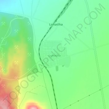
Name: Lohatlha topographic map, elevation, terrain.
Average elevation: 1,374 m
Minimum elevation: 1,327 m
Maximum elevation: 1,461 m
Thank you for supporting this site ❤️
Make a donation
Make a donation
Other topographic maps
Click on a map to view its topography, its elevation and its terrain.
Kumba - Kholomela Sishen South Anglo American Mine
South Africa > Northern Cape > ZF Mgcawu District Municipality > Tsantsabane Local Municipality
Average elevation: 1,283 m