
Make a donation
Pateley Bridge topographic map
Click on the map to display elevation.
Make a donation
About this map
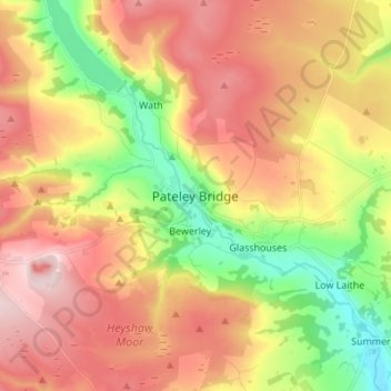
Name: Pateley Bridge topographic map, elevation, terrain.
Average elevation: 257 m
Minimum elevation: 86 m
Maximum elevation: 419 m
Make a donation
Other topographic maps
Click on a map to view its topography, its elevation and its terrain.
Malton
United Kingdom > England > North Yorkshire
As with the rest of the British Isles and Yorkshire, Malton possesses a maritime climate with cool summers and mild winters. The nearest Met Office weather station for which records are available is High Mowthorpe, about 6 miles (10 km) east of the town centre. Due to its lower elevation, the town centre is…
Average elevation: 28 m
Make a donation
Make a donation
Make a donation
Make a donation
Make a donation
Howe
United Kingdom > England > North Yorkshire > Hambleton > Skipton on Swale > Howe
Average elevation: 28 m
Make a donation
Craven
United Kingdom > England > North Yorkshire
Vegetation in the Pennines is adapted to subarctic climates, but altitude and acidity are also factors. For example, on Sutton Moor the millstone grit's topsoil below 275 m (902 ft) has a soil ph that is almost neutral, ph 6 to 7, and so grows good grazing. However, above 275 m (902 ft) it is acidic, ph 2 to…
Average elevation: 294 m
Exelby, Leeming and Londonderry
United Kingdom > England > North Yorkshire > Hambleton
Average elevation: 35 m
Great Ayton
United Kingdom > England > North Yorkshire > Hambleton > Great Ayton
Average elevation: 119 m
Make a donation
Milby Cut
United Kingdom > England > North Yorkshire > Harrogate > Aldborough > Milby
Average elevation: 20 m
Make a donation