
Umsobomvu Ward 2 topographic map
Interactive map
Click on the map to display elevation.
About this map
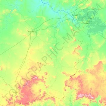
Name: Umsobomvu Ward 2 topographic map, elevation, terrain.
Average elevation: 1,424 m
Minimum elevation: 1,167 m
Maximum elevation: 2,088 m
Other topographic maps
Click on a map to view its topography, its elevation and its terrain.
Norvalspont
South Africa > Northern Cape > Pixley ka Seme District Municipality > Umsobomvu Local Municipality
Average elevation: 1,236 m
Oorlogspoort
South Africa > Northern Cape > Pixley ka Seme District Municipality > Umsobomvu Local Municipality
Average elevation: 1,285 m
Noupoort
South Africa > Northern Cape > Pixley ka Seme District Municipality > Umsobomvu Local Municipality
Average elevation: 1,541 m