
Make a donation
Mendoza topographic map
Click on the map to display elevation.
Make a donation
Mendoza
The area around Malargue is located at higher elevation (1400 meters) and thus the weather is significantly colder: summers average 28 °C (82 °F) during the day, but only 11 °C (53F) at night, and winters range from 10 °C (50 °F) to −2 °C (28 °F). Here, precipitation is somewhat higher (350 mm) and winter is stormier than the summer, with 45 mm (1.8 in) falling in July. Snow is much more common, and falls several times every year: on occasion, it can be heavy. Temperatures often fall to −12 °C (10 °F) and up to −23 °C (-9 °F) have been recorded.
Make a donation
About this map
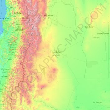
Name: Mendoza topographic map, elevation, terrain.
Location: Mendoza, Argentina (-37.57513 -70.58358 -31.99939 -66.47786)
Average elevation: 1,069 m
Minimum elevation: 0 m
Maximum elevation: 6,561 m
Make a donation
Other topographic maps
Click on a map to view its topography, its elevation and its terrain.
Aconcagua
Argentina > Mendoza > Distrito Las Cuevas
Aconcagua (Spanish pronunciation: [akoŋˈkaɣwa]) is a mountain in the Principal Cordillera of the Andes mountain range, in Mendoza Province, Argentina. It is the highest mountain in the Americas, the highest outside Asia, and the highest in both the Western Hemisphere and the Southern Hemisphere with a…
Average elevation: 6,201 m