
Ogulin topographic map
Interactive map
Click on the map to display elevation.
About this map
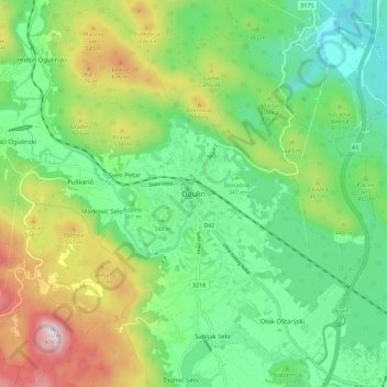
Name: Ogulin topographic map, elevation, terrain.
Location: Ogulin, Grad Ogulin, Karlovac County, 47300, Croatia (45.22586 15.18552 45.30586 15.26552)
Average elevation: 391 m
Minimum elevation: 188 m
Maximum elevation: 793 m
Other topographic maps
Click on a map to view its topography, its elevation and its terrain.
Lapovac
Lapovac, Grad Slunj, Karlovac County, Croatia
Average elevation: 226 m