
Thank you for supporting this site ❤️
Make a donation
Make a donation
Kent County topographic map
Click on the map to display elevation.
Thank you for supporting this site ❤️
Make a donation
Make a donation
About this map
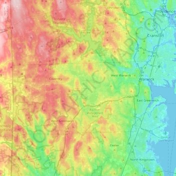
Name: Kent County topographic map, elevation, terrain.
Location: Kent County, Rhode Island, United States (41.59676 -71.78970 41.76833 -71.35666)
Average elevation: 92 m
Minimum elevation: -7 m
Maximum elevation: 241 m
Thank you for supporting this site ❤️
Make a donation
Make a donation
Other topographic maps
Click on a map to view its topography, its elevation and its terrain.
Clayville
United States > Rhode Island > Providence County > Scituate > Clayville
Average elevation: 139 m