
Thank you for supporting this site ❤️
Make a donation
Make a donation
Queen River topographic map
Click on the map to display elevation.
Thank you for supporting this site ❤️
Make a donation
Make a donation
About this map
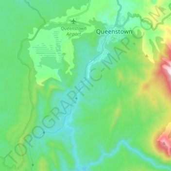
Name: Queen River topographic map, elevation, terrain.
Location: Queen River, Queenstown, West Coast, Tasmania, Australia (-42.15616 145.51888 -42.06333 145.56173)
Average elevation: 277 m
Minimum elevation: 42 m
Maximum elevation: 1,048 m
Thank you for supporting this site ❤️
Make a donation
Make a donation