Geolocate

Staffa topographic map

Click on the map to display elevation.

About this map

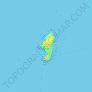
Name: Staffa topographic map, elevation, terrain.

Location: Staffa, Argyll and Bute, Scotland, United Kingdom (56.43122 -6.34683 56.44047 -6.33673)

Average elevation: 0 m

Minimum elevation: -1 m

Maximum elevation: 30 m

Other topographic maps

Click on a map to view its topography, its elevation and its terrain.

Mull

United Kingdom > Scotland > Argyll and Bute

Average elevation: 122 m

Islay

United Kingdom > Scotland > Argyll and Bute

Average elevation: 53 m

Bunessan

United Kingdom > Scotland > Argyll and Bute

Average elevation: 32 m

Seil

United Kingdom > Scotland > Argyll and Bute > Clachan-Seil

Average elevation: 16 m

Crossaig

United Kingdom > Scotland > Argyll and Bute

Average elevation: 72 m

Coll

United Kingdom > Scotland > Argyll and Bute > Arinagour

Average elevation: 7 m

Luss

United Kingdom > Scotland > Argyll and Bute

Average elevation: 97 m

Edendonich

United Kingdom > Scotland > Argyll and Bute > Dalmally

Average elevation: 149 m

Portincaple

United Kingdom > Scotland > Argyll and Bute

Average elevation: 100 m

Cladich

United Kingdom > Scotland > Argyll and Bute

Average elevation: 119 m

Ben Vorlich

United Kingdom > Scotland > Argyll and Bute

Average elevation: 576 m

Tom Buidhe

United Kingdom > Scotland > Argyll and Bute

Average elevation: 218 m

Ben Vane

United Kingdom > Scotland > Argyll and Bute

Average elevation: 494 m

Beinn an Lochain

United Kingdom > Scotland > Argyll and Bute

Although included in Sir Hugh Munro's original list of Scottish mountains over 3,000 feet (914.4 metres) summit elevation, subsequent surveys showed it to be significantly shorter than this. Nonetheless, it remains a popular mountain, and is often quoted as an example of an interesting mountain below the Munro…

Average elevation: 422 m

Ben Donich

United Kingdom > Scotland > Argyll and Bute

Average elevation: 518 m

Cnoc Moy

United Kingdom > Scotland > Argyll and Bute

Average elevation: 246 m

Loch Ba

United Kingdom > Scotland > Argyll and Bute

Average elevation: 141 m

Bowmore

United Kingdom > Scotland > Argyll and Bute

Average elevation: 13 m

Ardminish

United Kingdom > Scotland > Argyll and Bute

Average elevation: 9 m

Arinagour

United Kingdom > Scotland > Argyll and Bute

Average elevation: 21 m

Kerrera

United Kingdom > Scotland > Argyll and Bute > Oban

Average elevation: 34 m

Helensburgh

United Kingdom > Scotland > Argyll and Bute

Average elevation: 63 m

Oban

United Kingdom > Scotland > Argyll and Bute

Average elevation: 52 m

Scalasaig

United Kingdom > Scotland > Argyll and Bute

Average elevation: 30 m

Dunoon

United Kingdom > Scotland > Argyll and Bute

Average elevation: 98 m

Ben Cruachan

United Kingdom > Scotland > Argyll and Bute

Average elevation: 721 m

Beinn Dubh

United Kingdom > Scotland > Argyll and Bute

Average elevation: 470 m

Loch Awe

United Kingdom > Scotland > Argyll and Bute > Lochawe

Average elevation: 218 m

Peaton

United Kingdom > Scotland > Argyll and Bute

Average elevation: 66 m

Colintraive

United Kingdom > Scotland > Argyll and Bute

Average elevation: 122 m

Bute

United Kingdom > Scotland > Argyll and Bute > Ardbeg

Average elevation: 41 m

Muasdale

United Kingdom > Scotland > Argyll and Bute

Average elevation: 62 m

Loch Tulla

United Kingdom > Scotland > Argyll and Bute

Average elevation: 210 m

Mannal

United Kingdom > Scotland > Argyll and Bute > Balemartine

Average elevation: 13 m

Colonsay

United Kingdom > Scotland > Argyll and Bute > Scalasaig

Average elevation: 11 m

Blairmore

United Kingdom > Scotland > Argyll and Bute

Average elevation: 61 m

Port Lamont

United Kingdom > Scotland > Argyll and Bute

Average elevation: 42 m

Campbeltown

United Kingdom > Scotland > Argyll and Bute

Average elevation: 84 m

Tayinloan

United Kingdom > Scotland > Argyll and Bute

Average elevation: 64 m

The Slate

United Kingdom > Scotland > Argyll and Bute

Average elevation: 242 m

Ardkinglas

United Kingdom > Scotland > Argyll and Bute > Cairndow

Average elevation: 172 m

Succoth

United Kingdom > Scotland > Argyll and Bute

Average elevation: 235 m

Carradale

United Kingdom > Scotland > Argyll and Bute

Average elevation: 37 m

Ormsary

United Kingdom > Scotland > Argyll and Bute

Average elevation: 70 m

Tullochgorm

United Kingdom > Scotland > Argyll and Bute > Minard

Average elevation: 82 m

Strachur

United Kingdom > Scotland > Argyll and Bute

The area around Strachur borders the Loch Lomond and the Trossachs National Park. The parish is bounded along its north-west side by Loch Fyne - Strachur forming its north-western district, and Strathlachlan its south-western one; and it is bounded on other sides by the parishes of Lochgoilhead, Kilmun,…

Average elevation: 125 m

Kames

United Kingdom > Scotland > Argyll and Bute

Average elevation: 56 m

Loch Etive

United Kingdom > Scotland > Argyll and Bute > Connel

Average elevation: 318 m

Ben More

United Kingdom > Scotland > Argyll and Bute

Ben More (Scottish Gaelic: Beinn Mhòr, meaning "great mountain") is the highest mountain and only Munro (mountains in Scotland that reach an elevation of at least 3,000 feet or 914.4 metres) on the Isle of Mull, Scotland. It is also the highest peak in the Scottish isles – and the only Munro – apart from…

Average elevation: 574 m

Cairnbaan

United Kingdom > Scotland > Argyll and Bute

Average elevation: 68 m

Beinn Bhàn

United Kingdom > Scotland > Argyll and Bute

Average elevation: 162 m

Airds Bay

United Kingdom > Scotland > Argyll and Bute > Taynuilt

Average elevation: 43 m

Lochbuie

United Kingdom > Scotland > Argyll and Bute

Average elevation: 119 m

Saddell

United Kingdom > Scotland > Argyll and Bute

Average elevation: 89 m

Port Askaig

United Kingdom > Scotland > Argyll and Bute

Average elevation: 45 m

Ascog

United Kingdom > Scotland > Argyll and Bute

Average elevation: 22 m

Toberonochy

United Kingdom > Scotland > Argyll and Bute

Average elevation: 15 m

Clachan

United Kingdom > Scotland > Argyll and Bute

Average elevation: 75 m

Cullipool

United Kingdom > Scotland > Argyll and Bute

Average elevation: 12 m

Strone

United Kingdom > Scotland > Argyll and Bute

Average elevation: 58 m

Glenfyne

United Kingdom > Scotland > Argyll and Bute

Average elevation: 328 m

Leanach

United Kingdom > Scotland > Argyll and Bute

Average elevation: 131 m

Portnahaven

United Kingdom > Scotland > Argyll and Bute

Average elevation: 13 m

Kilchoman

United Kingdom > Scotland > Argyll and Bute

Average elevation: 48 m

Ardfin

United Kingdom > Scotland > Argyll and Bute

Average elevation: 57 m

Lochgilphead

United Kingdom > Scotland > Argyll and Bute

Average elevation: 102 m

Ford

United Kingdom > Scotland > Argyll and Bute

Average elevation: 125 m

Loch Fyne

United Kingdom > Scotland > Argyll and Bute > Inveraray

Average elevation: 137 m

Garelochhead

United Kingdom > Scotland > Argyll and Bute

Average elevation: 110 m

Taynuilt

United Kingdom > Scotland > Argyll and Bute

Average elevation: 49 m

Fearnoch

United Kingdom > Scotland > Argyll and Bute

Average elevation: 67 m

Easdale

United Kingdom > Scotland > Argyll and Bute > Easdale

Average elevation: 8 m