
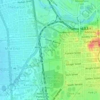
Ellis Park topographic map
Interactive map
Click on the map to display elevation.
About this map
Name: Ellis Park topographic map, elevation, terrain.
Average elevation: 33 m
Minimum elevation: 16 m
Maximum elevation: 77 m
Adelaide is a planned city, and the Adelaide Park Lands are an integral part of Colonel William Light's 1837 plan. Light chose a site spanning the River Torrens (known as Yatala by the local people), and planned the city to fit the topography of the landscape, "on rising ground".
Other topographic maps
Click on a map to view its topography, its elevation and its terrain.
Fullarton
Australia > South Australia > Adelaide
Fullarton, Adelaide, City of Unley, South Australia, 5063, Australia
Average elevation: 78 m
West Beach
Australia > South Australia > Adelaide
West Beach, Adelaide, City of West Torrens, South Australia, 5024, Australia
Average elevation: 5 m
Elizabeth South
Australia > South Australia > Adelaide
Elizabeth South, Adelaide, City of Playford, South Australia, 5112, Australia
Average elevation: 39 m