
Védrinettes topographic map
Interactive map
Click on the map to display elevation.
About this map
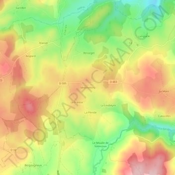
Name: Védrinettes topographic map, elevation, terrain.
Average elevation: 971 m
Minimum elevation: 857 m
Maximum elevation: 1,074 m
Other topographic maps
Click on a map to view its topography, its elevation and its terrain.
Langlade
France > Auvergne-Rhône-Alpes > Haute-Loire > Cubelles
Langlade, Cubelles, Brioude, Haute-Loire, Auvergne-Rhône-Alpes, France métropolitaine, 43170, France
Average elevation: 915 m
Le Mont
France > Auvergne-Rhône-Alpes > Haute-Loire > Cubelles
Le Mont, Cubelles, Brioude, Haute-Loire, Auvergne-Rhône-Alpes, France métropolitaine, 43170, France
Average elevation: 942 m