
Make a donation
Middle Tennessee topographic map
Click on the map to display elevation.
Make a donation
Middle Tennessee
The Highland Rim is often divided into eastern and western halves. The Eastern Highland Rim is relatively flat, with gentle rolling hills, and the eastern Nashville Basin has similar terrain but is dotted with more distinct hills in places. The western Nashville Basin and Western Highland Rim are more rugged, consisting of irregular knob-like hills separated by steep ravines and crooked stream valleys. The eastern Highland Rim has a higher average elevation, however, than the western portion. The eastern portion of Middle Tennessee consists of the western portion of the Cumberland Plateau, part of the larger Appalachian Plateau of the Appalachian Mountains.
Make a donation
About this map
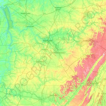
Name: Middle Tennessee topographic map, elevation, terrain.
Location: Middle Tennessee, Tennessee, United States (34.98825 -88.07053 36.67812 -84.65953)
Average elevation: 251 m
Minimum elevation: 96 m
Maximum elevation: 874 m
Make a donation
Other topographic maps
Click on a map to view its topography, its elevation and its terrain.
Make a donation
Make a donation
Make a donation
Make a donation
Make a donation
Make a donation
Make a donation
Make a donation
Murray Lane Estates
United States > Tennessee > Williamson County > Brentwood
Average elevation: 240 m
Make a donation
Mount Le Conte
United States > Tennessee > Sevier County
Mount Le Conte (or LeConte) is a mountain located within the Great Smoky Mountains National Park in Sevier County, Tennessee. At 6,593 ft (2,010 m) it is the third highest peak in the national park, behind Kuwohi (formerly Clingmans Dome) (6,643 ft (2,025 m)) and Mount Guyot (6,621 ft (2,018 m)). It is also…
Average elevation: 1,661 m
Make a donation
Make a donation
Shepherd Forest
United States > Tennessee > Hamilton County > Signal Mountain
Average elevation: 459 m
Make a donation
Harpeth River Greenway
United States > Tennessee > Davidson County > Nashville > Harpeth River Estates
Average elevation: 182 m
Make a donation
Make a donation
Make a donation
Make a donation
Make a donation
Make a donation
Greenfield Heights
United States > Tennessee > Washington County > Johnson City
Average elevation: 499 m
Make a donation
Make a donation
House Mountain
United States > Tennessee > Knox County
House Mountain is a mountain located in Corryton, Tennessee, United States, about 8 miles (13 km) northeast of Knoxville. Rising to an elevation of 2,064 feet (629 m) above sea level, House Mountain is the highest point in Knox County.
Average elevation: 394 m
Make a donation
Sugarlands
United States > Tennessee > Sevier County
In the 19the century, mountain areas became popular vacation destinations, especially since large urban areas were often wanting for clean air and scenery. Mineral-rich mountain springs were thought to have health-restoring qualities, and the cool air of the higher elevations lured people seeking relief from…
Average elevation: 607 m
Make a donation
Make a donation
Make a donation
Belle Rive Highlands
United States > Tennessee > Williamson County > Brentwood
Average elevation: 224 m
Make a donation