Wates topographic map
Interactive map
Click on the map to display elevation.
About this map
![Wates topographic map, elevation, terrain](/pub/maps/node/hzgp/gjfzddnx/thumbnail.jpg)
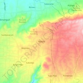
Name: Wates topographic map, elevation, terrain.
Location: Wates, Blitar, East Java, Java, 66194, Indonesia (-8.29508 112.33190 -8.21508 112.41190)
Average elevation: 363 m
Minimum elevation: 174 m
Maximum elevation: 557 m
Other topographic maps
Click on a map to view its topography, its elevation and its terrain.
![Gunung Kidul topographic map, elevation, terrain](/pub/maps/node/gjb3/tzmpmgdn/icon.jpg)
Gunung Kidul
Indonesia > East Java > Blitar
Gunung Kidul, Blitar, East Java, Java, Indonesia
Average elevation: 151 m
![Gunung Buthak Kawi topographic map, elevation, terrain](/pub/maps/node/dks8/lp7fbx4s/icon.jpg)
Gunung Buthak Kawi
Indonesia > East Java > Blitar
Gunung Buthak Kawi, Blitar, East Java, Java, Indonesia
Average elevation: 2,424 m
![Mount Kelud topographic map, elevation, terrain](/pub/maps/node/ntm2/cn2cz1h/icon.jpg)
Mount Kelud
Indonesia > East Java > Blitar
Mount Kelud, Blitar, East Java, Java, Indonesia
Average elevation: 1,293 m