
Camden County topographic map
Interactive map
Click on the map to display elevation.
About this map
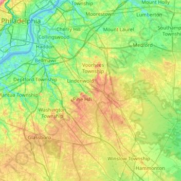
Name: Camden County topographic map, elevation, terrain.
Location: Camden County, New Jersey, USA (39.60829 -75.13983 39.99608 -74.73631)
Average elevation: 26 m
Minimum elevation: -3 m
Maximum elevation: 79 m
Other topographic maps
Click on a map to view its topography, its elevation and its terrain.
New Brunswick
USA > New Jersey > New Brunswick
New Brunswick, Middlesex County, New Jersey, USA
Average elevation: 25 m
National Park
USA > New Jersey > National Park
National Park, Gloucester County, New Jersey, 08063, USA
Average elevation: 4 m
Granite Peak
Granite Peak, Sussex County, New Jersey, 07472, USA
Average elevation: 332 m