
Communications Hill topographic map
Interactive map
Click on the map to display elevation.
About this map
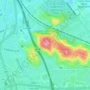
Name: Communications Hill topographic map, elevation, terrain.
Average elevation: 54 m
Minimum elevation: 29 m
Maximum elevation: 131 m
Other topographic maps
Click on a map to view its topography, its elevation and its terrain.
Calero Reservoir
USA > California > San Jose
Calero Reservoir, Cottle Trail, San Jose, Santa Clara County, California, 951320, USA
Average elevation: 193 m
Martial Cottle Park
USA > California > San Jose
Martial Cottle Park, Almaden Valley, San Jose, Santa Clara County, California, USA
Average elevation: 51 m