
Merrimack topographic map
Interactive map
Click on the map to display elevation.
About this map
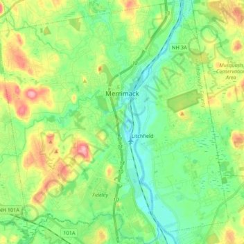
Name: Merrimack topographic map, elevation, terrain.
Average elevation: 68 m
Minimum elevation: 27 m
Maximum elevation: 150 m
Other topographic maps
Click on a map to view its topography, its elevation and its terrain.
Ward 9
United States > New Hampshire > Hillsborough County > Nashua
Ward 9, Nashua, Hillsborough County, New Hampshire, United States
Average elevation: 70 m
Ward 8
United States > New Hampshire > Hillsborough County > Nashua
Ward 8, Nashua, Hillsborough County, New Hampshire, United States
Average elevation: 73 m