
Make a donation
Shurugwi topographic map
Click on the map to display elevation.
Make a donation
About this map
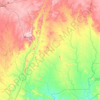
Name: Shurugwi topographic map, elevation, terrain.
Location: Shurugwi, Midlands Province, Zimbabwe (-20.07842 29.78543 -19.42935 30.48827)
Average elevation: 1,182 m
Minimum elevation: 921 m
Maximum elevation: 1,557 m
Make a donation
Other topographic maps
Click on a map to view its topography, its elevation and its terrain.
Kwekwe
Zimbabwe > Midlands Province > Kwekwe
The town is situated on Zimbabwe's Highveld at an altitude of 1,220 metres (4,000 ft), above sea level. It is located in the tropics but its high altitude modifies this to a warm temperate or humid subtropical climate.
Average elevation: 1,200 m
Kwekwe
Zimbabwe > Midlands Province > Kwekwe
The town is situated on Zimbabwe's Highveld at an altitude of 1,220 metres (4,000 ft), above sea level. It is located in the tropics but its high altitude modifies this to a warm temperate or humid subtropical climate.
Average elevation: 1,200 m
Make a donation
Make a donation