
Make a donation
Bradley topographic map
Click on the map to display elevation.
Make a donation
Bradley
Bradley is an unincorporated community and census-designated place (CDP) in Monterey County, California, on the Salinas River 14 miles (23 km) south-southeast of San Ardo and 20 miles (32 km) north of Paso Robles. Bradley sits at an elevation of 548 feet (167 m). The population was 69 at the 2020 census, down from 93 at the 2010 census.
Make a donation
About this map
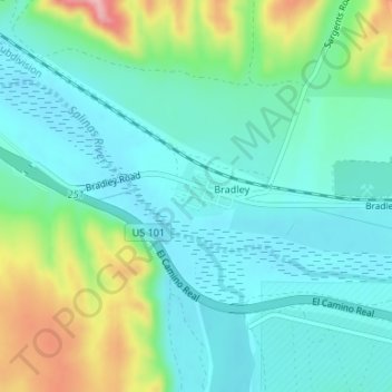
Name: Bradley topographic map, elevation, terrain.
Location: Bradley, Monterey County, California, United States (35.86092 -120.80934 35.86462 -120.79867)
Average elevation: 190 m
Minimum elevation: 149 m
Maximum elevation: 309 m
Make a donation
Other topographic maps
Click on a map to view its topography, its elevation and its terrain.
Prunedale
United States > California > Monterey County
Prunedale is a unincorporated community in Monterey County, California, United States. It is located 8 miles (13 km) north of Salinas at an elevation of 92 feet (28 m). The population was 18,885 as of the 2020 census, up from 17,560 in 2010. For statistical purposes, the United States Census Bureau has defined…
Average elevation: 104 m
Make a donation
Pfeiffer Big Sur State Park
United States > California > Monterey County > Big Sur Village
Average elevation: 302 m
Prunedale
United States > California > Monterey County > Prunedale
Prunedale is a census-designated place in Monterey County, California. Prunedale is located 8 miles (13 km) north of Salinas, at an elevation of 92 feet (28 m). The population was 17,560 residents at the time of the 2010 census, up from 16,432 at the 2000 census. Plum trees were grown in Prunedale in the early…
Average elevation: 69 m
Make a donation
Make a donation
Sand City
United States > California > Monterey County
Sand City is a city in Monterey County, California, United States, located on the shores of Monterey Bay, and surrounded on most sides by the larger city of Seaside. Sand City is located 2 miles (3 km) northeast of Monterey, at an elevation of 72 feet (22 m). The population was 325 at the 2020 census. The city…
Average elevation: 11 m
Greenfield
United States > California > Monterey County
Greenfield is a city in Monterey County, California, United States. Formerly Clarke Colony, it lies in the Salinas Valley, 33 miles (53 km) southeast of Salinas, at an elevation of 289 feet (88 m). As of the 2020 census, the population was 18,937, up from 16,330 in the 2010 census. Its most well-known public…
Average elevation: 86 m
Make a donation