
Thank you for supporting this site ❤️
Make a donation
Make a donation
Harmony topographic map
Click on the map to display elevation.
Thank you for supporting this site ❤️
Make a donation
Make a donation
About this map
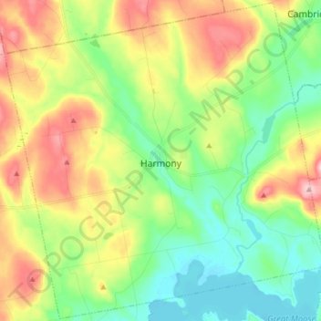
Name: Harmony topographic map, elevation, terrain.
Location: Harmony, Somerset County, Maine, 04942, United States (44.92137 -69.62097 45.02833 -69.46766)
Average elevation: 146 m
Minimum elevation: 69 m
Maximum elevation: 272 m
Thank you for supporting this site ❤️
Make a donation
Make a donation
Other topographic maps
Click on a map to view its topography, its elevation and its terrain.
No Name Pond
United States > Maine > Somerset County > Bald Mountain Township T4 R3
Average elevation: 686 m
Thank you for supporting this site ❤️
Make a donation
Make a donation