
Grand Coo topographic map
Interactive map
Click on the map to display elevation.
About this map
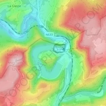
Name: Grand Coo topographic map, elevation, terrain.
Location: Grand Coo, Stavelot, Verviers, Luik, Wallonië, 4970, België (50.37337 5.84957 50.41337 5.88957)
Average elevation: 345 m
Minimum elevation: 203 m
Maximum elevation: 517 m
Other topographic maps
Click on a map to view its topography, its elevation and its terrain.
La Vaulx Richard
België > Luik > Verviers > Stavelot
La Vaulx Richard, Stavelot, Verviers, Luik, Wallonië, 4970, België
Average elevation: 397 m
Francorchamps
België > Luik > Verviers > Stavelot
Francorchamps, Stavelot, Verviers, Luik, Wallonië, 4970, België
Average elevation: 482 m