
Thank you for supporting this site ❤️
Make a donation
Make a donation
Trautskirchen topographic map
Click on the map to display elevation.
Thank you for supporting this site ❤️
Make a donation
Make a donation
About this map
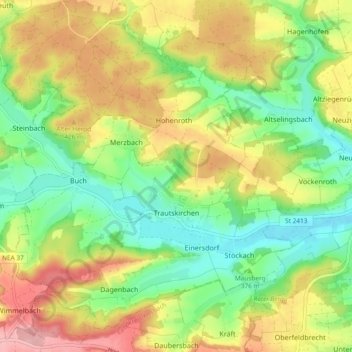
Name: Trautskirchen topographic map, elevation, terrain.
Average elevation: 392 m
Minimum elevation: 325 m
Maximum elevation: 479 m
Thank you for supporting this site ❤️
Make a donation
Make a donation
Other topographic maps
Click on a map to view its topography, its elevation and its terrain.
Willmersbach
Germany > Bavaria > Landkreis Neustadt an der Aisch-Bad Windsheim
Average elevation: 337 m
Marberg
Germany > Bavaria > Landkreis Neustadt an der Aisch-Bad Windsheim > Neustadt an der Aisch
Average elevation: 308 m