
Make a donation
Pottsville topographic map
Click on the map to display elevation.
Make a donation
Pottsville
Pottsville experiences a humid subtropical climate (Cfa) according to the Köppen climate classification system if the 26.6 °F (−3.0 °C) isotherm is used, or a humid continental climate (Dfa) if the 32 °F (0 °C) isotherm is used. The record high was 104 °F (40 °C) in 2011, and the record low was −19 °F (−28 °C) in 1994. Average monthly temperatures range from 27.3 °F in January to 72.3 °F in July. [2] The hardiness zone is 6b or 7a depending upon elevation. [3]
Make a donation
About this map
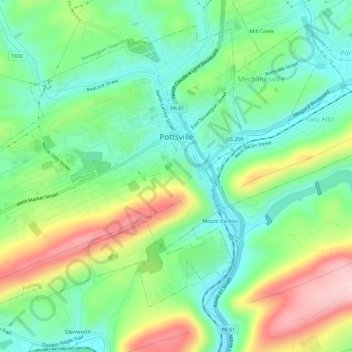
Name: Pottsville topographic map, elevation, terrain.
Average elevation: 262 m
Minimum elevation: 174 m
Maximum elevation: 426 m
Make a donation
Other topographic maps
Click on a map to view its topography, its elevation and its terrain.
Park Place
United States > Pennsylvania > Schuylkill County > Mahanoy Township
Average elevation: 515 m
Snyders
United States > Pennsylvania > Schuylkill County > West Penn Township
Average elevation: 242 m
Blue Mountain
United States > Pennsylvania > Schuylkill County > Washington Township
The ridge of Blue Mountain runs for 150 miles (240 km) through Pennsylvania, reaching an elevation of 2,270 feet (690 m) above sea level just north of the Pennsylvania Turnpike, near the borough of Newburg. Most of the ridgecrest, however, only reaches between 1,400 and 1,700 feet (430 and 520 m) in elevation.…
Average elevation: 226 m
Make a donation
Andreas
United States > Pennsylvania > Schuylkill County > West Penn Township
Average elevation: 250 m
Blue Mountain
United States > Pennsylvania > Schuylkill County > Washington Township
The ridge of Blue Mountain runs for 150 miles (240 km) through Pennsylvania, reaching an elevation of 2,270 feet (690 m) above sea level just north of the Pennsylvania Turnpike, near the borough of Newburg. Most of the ridgecrest, however, only reaches between 1,400 and 1,700 feet (430 and 520 m) in elevation.…
Average elevation: 226 m
Irving
United States > Pennsylvania > Schuylkill County > Pine Grove Township
Average elevation: 199 m
Make a donation
Andreas
United States > Pennsylvania > Schuylkill County > West Penn Township
Average elevation: 250 m
Blue Mountain
United States > Pennsylvania > Schuylkill County > Washington Township
The ridge of Blue Mountain runs for 150 miles (240 km) through Pennsylvania, reaching an elevation of 2,270 feet (690 m) above sea level just north of the Pennsylvania Turnpike, near the borough of Newburg. Most of the ridgecrest, however, only reaches between 1,400 and 1,700 feet (430 and 520 m) in elevation.…
Average elevation: 226 m
Make a donation
Nuremberg
United States > Pennsylvania > Schuylkill County > North Union Township
Average elevation: 377 m