
Senekal topographic map
Click on the map to display elevation.
About this map
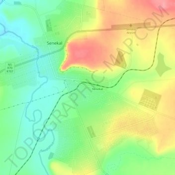
Name: Senekal topographic map, elevation, terrain.
Average elevation: 1,451 m
Minimum elevation: 1,412 m
Maximum elevation: 1,501 m
Other topographic maps
Click on a map to view its topography, its elevation and its terrain.
Ficksburg
South Africa > Free State > Thabo Mofutsanyana District Municipality > Setsoto Local Municipality
Average elevation: 1,617 m
Hlohlolwane (Clocolan)
South Africa > Free State > Thabo Mofutsanyana District Municipality > Setsoto Local Municipality
Average elevation: 1,593 m
Marquard
South Africa > Free State > Thabo Mofutsanyana District Municipality > Setsoto Local Municipality
Average elevation: 1,512 m
Allemanskraal Dam
South Africa > Free State > Thabo Mofutsanyana District Municipality > Setsoto Local Municipality > Aldam
Average elevation: 1,421 m
Ficksburg
South Africa > Free State > Thabo Mofutsanyana District Municipality > Setsoto Local Municipality
Average elevation: 1,617 m
Meqheleng
South Africa > Free State > Thabo Mofutsanyana District Municipality > Setsoto Local Municipality
Average elevation: 1,599 m
Marquard
South Africa > Free State > Thabo Mofutsanyana District Municipality > Setsoto Local Municipality
Average elevation: 1,512 m
Hlohlolwane (Clocolan)
South Africa > Free State > Thabo Mofutsanyana District Municipality > Setsoto Local Municipality
Average elevation: 1,593 m