
Make a donation
Courtice topographic map
Click on the map to display elevation.
Make a donation
About this map
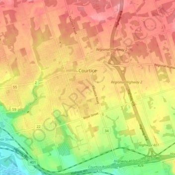
Name: Courtice topographic map, elevation, terrain.
Location: Courtice, Durham Region, Golden Horseshoe, Ontario, Canada (43.87536 -78.82204 43.93630 -78.75314)
Average elevation: 129 m
Minimum elevation: 73 m
Maximum elevation: 166 m
Make a donation
Other topographic maps
Click on a map to view its topography, its elevation and its terrain.
Pickering
Canada > Ontario > Durham Region
The city covers an area of 231 square kilometres (89 sq mi) with an elevation of 89 metres (292 ft).
Average elevation: 170 m
Make a donation
Make a donation
Make a donation
Lake Scugog
Canada > Ontario > Durham Region > Kawartha Lakes
The stagnant waters of the lake caused a wave of deadly fevers in the surrounding farms, and the new lake limits quickly became very unpopular with the local residents. On one day in the summer of 1838, settlers from the countryside surrounding the lake rose up and using axes, flintlocks and pitchforks, tore…
Average elevation: 269 m
Make a donation
Make a donation
Make a donation
Make a donation
Make a donation
Make a donation
Make a donation
Make a donation
Pickering
Canada > Ontario > Durham Region
The city covers an area of 231 square kilometres (89 sq mi) with an elevation of 89 metres (292 ft).
Average elevation: 170 m
Make a donation
Pickering
Canada > Ontario > Durham Region
The city covers an area of 231 square kilometres (89 sq mi) with an elevation of 89 metres (292 ft).
Average elevation: 170 m
Pickering
Canada > Ontario > Durham Region
The city covers an area of 231 square kilometres (89 sq mi) with an elevation of 89 metres (292 ft).
Average elevation: 170 m
Make a donation