
Adansi North District topographic map
Interactive map
Click on the map to display elevation.
About this map
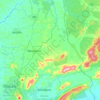
Name: Adansi North District topographic map, elevation, terrain.
Location: Adansi North District, Ashanti Region, Ghana (6.23352 -1.70943 6.36780 -1.46139)
Average elevation: 235 m
Minimum elevation: 147 m
Maximum elevation: 596 m
Other topographic maps
Click on a map to view its topography, its elevation and its terrain.
Obuasi
Ghana > Ashanti Region > Obuasi Municipal District
Obuasi, Obuasi Municipal District, Ashanti Region, Ghana
Average elevation: 196 m
Wiawso
Ghana > Ashanti Region > Ahafo-Ano South West District > Wiawso
Wiawso, Ahafo-Ano South West District, Ashanti Region, Ghana
Average elevation: 326 m
Adansi Prasu
Ghana > Ashanti Region > Adansi Prasu
Adansi Prasu, Ashanti Region, Ghana
Average elevation: 99 m