
鄂尔多斯市 topographic map
Interactive map
Click on the map to display elevation.
About this map
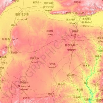
Name: 鄂尔多斯市 topographic map, elevation, terrain.
Location: 鄂尔多斯市, Mongólia Interior, China (37.61705 106.47765 40.87082 111.45685)
Average elevation: 1,260 m
Minimum elevation: 666 m
Maximum elevation: 2,313 m
Other topographic maps
Click on a map to view its topography, its elevation and its terrain.
康巴什区
康巴什区, 鄂尔多斯市, Mongólia Interior, 017010, China
Average elevation: 1,361 m
鄂尔多斯市
China > Mongólia Interior > 鄂尔多斯市
鄂尔多斯市, 康巴什区, Ордос / 鄂尔多斯市 / Ordos, Mongólia Interior, 017010, China
Average elevation: 1,372 m