
Thank you for supporting this site ❤️
Make a donation
Make a donation
Monroe topographic map
Click on the map to display elevation.
Thank you for supporting this site ❤️
Make a donation
Make a donation
About this map
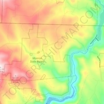
Name: Monroe topographic map, elevation, terrain.
Location: Monroe, Franklin County, Massachusetts, 01350, United States (42.70126 -73.02371 42.74114 -72.92719)
Average elevation: 553 m
Minimum elevation: 252 m
Maximum elevation: 859 m
Thank you for supporting this site ❤️
Make a donation
Make a donation
Other topographic maps
Click on a map to view its topography, its elevation and its terrain.
North Sunderland
United States > Massachusetts > Franklin County > Sunderland
Average elevation: 100 m
Thank you for supporting this site ❤️
Make a donation
Make a donation
Thank you for supporting this site ❤️
Make a donation
Make a donation
Thank you for supporting this site ❤️
Make a donation
Make a donation