
Thank you for supporting this site ❤️
Make a donation
Make a donation
Waltenhofen topographic map
Click on the map to display elevation.
Thank you for supporting this site ❤️
Make a donation
Make a donation
About this map
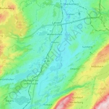
Name: Waltenhofen topographic map, elevation, terrain.
Location: Waltenhofen, Landkreis Oberallgäu, Bavaria, 87448, Germany (47.60596 10.17659 47.70115 10.32492)
Average elevation: 780 m
Minimum elevation: 682 m
Maximum elevation: 1,095 m
Thank you for supporting this site ❤️
Make a donation
Make a donation
Other topographic maps
Click on a map to view its topography, its elevation and its terrain.
Immenstadt im Allgäu
Germany > Bavaria > Landkreis Oberallgäu > Immenstadt im Allgäu
Average elevation: 910 m
Thank you for supporting this site ❤️
Make a donation
Make a donation
Holdenried
Germany > Bavaria > Landkreis Oberallgäu > Wiggensbach > Wiggensbach
Average elevation: 904 m
Thank you for supporting this site ❤️
Make a donation
Make a donation
Thank you for supporting this site ❤️
Make a donation
Make a donation