
Sundern topographic map
Interactive map
Click on the map to display elevation.
About this map
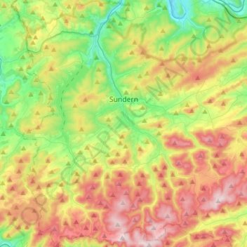
Name: Sundern topographic map, elevation, terrain.
Average elevation: 381 m
Minimum elevation: 179 m
Maximum elevation: 655 m
Die Burg Hachen ist die Ruine einer Höhenburg, die um 1000 auf einer Berghöhe im Stadtteil Hachen erbaut wurde.
Other topographic maps
Click on a map to view its topography, its elevation and its terrain.
Berge
Deutschland > Nordrhein-Westfalen > Hochsauerlandkreis > Meschede
Berge, Meschede, Hochsauerlandkreis, Nordrhein-Westfalen, Deutschland
Average elevation: 326 m
Bestwig
Deutschland > Nordrhein-Westfalen > Hochsauerlandkreis
Bestwig, Hochsauerlandkreis, Nordrhein-Westfalen, 59909, Deutschland
Average elevation: 466 m