
Thank you for supporting this site ❤️
Make a donation
Make a donation
Allersdorf topographic map
Click on the map to display elevation.
Thank you for supporting this site ❤️
Make a donation
Make a donation
About this map
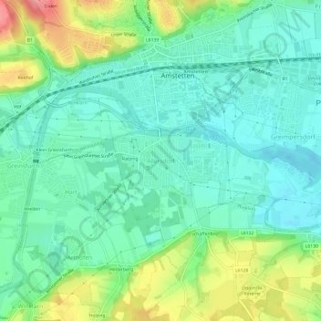
Name: Allersdorf topographic map, elevation, terrain.
Average elevation: 287 m
Minimum elevation: 257 m
Maximum elevation: 359 m
Thank you for supporting this site ❤️
Make a donation
Make a donation
Other topographic maps
Click on a map to view its topography, its elevation and its terrain.
3300
Österreich > Niederösterreich > Bezirk Amstetten > Amstetten > Allersdorf
Average elevation: 299 m
Spiegelsberg
Österreich > Niederösterreich > Bezirk Amstetten > Amstetten > Spiegelsberg
Average elevation: 308 m