
Purulhá topographic map
Interactive map
Click on the map to display elevation.
About this map
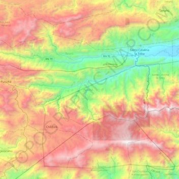
Name: Purulhá topographic map, elevation, terrain.
Location: Purulhá, Baja Verapaz, Guatemala (15.12795 -90.32810 15.30366 -89.85937)
Average elevation: 1,376 m
Minimum elevation: 29 m
Maximum elevation: 2,950 m
Other topographic maps
Click on a map to view its topography, its elevation and its terrain.
Granados Baja Verapaz
Granados Baja Verapaz, Baja Verapaz, Guatemala
Average elevation: 1,376 m
San Jerónimo
Guatemala > Baja Verapaz > San Jerónimo
San Jerónimo, Baja Verapaz, 15002, Guatemala
Average elevation: 1,255 m
Santa Cruz el Chol
Guatemala > Baja Verapaz > Santa Cruz el Chol
Santa Cruz el Chol, Baja Verapaz, Guatemala
Average elevation: 1,156 m
Río Negro
Guatemala > Baja Verapaz > San Jerónimo > San Jerónimo
Río Negro, San Jerónimo, Baja Verapaz, 15001, Guatemala
Average elevation: 1,339 m
Biotopo del Quetzal
Guatemala > Baja Verapaz > Purulhá
Biotopo del Quetzal, Juan Xoccaal, Purulhá, Baja Verapaz, Guatemala
Average elevation: 1,801 m
San Miguel Chicaj
San Miguel Chicaj, Baja Verapaz, Guatemala
Average elevation: 1,313 m
San Miguel Chicaj
Guatemala > Baja Verapaz > San Miguel Chicaj
San Miguel Chicaj, Baja Verapaz, Guatemala
Average elevation: 1,122 m