
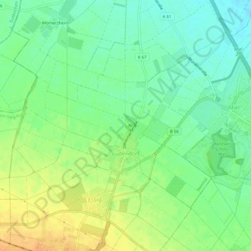
Ludendorf topographic map
Interactive map
Click on the map to display elevation.
About this map
Name: Ludendorf topographic map, elevation, terrain.
Average elevation: 153 m
Minimum elevation: 139 m
Maximum elevation: 171 m
Other topographic maps
Click on a map to view its topography, its elevation and its terrain.
Straßfeld
Deutschland > Nordrhein-Westfalen > Rhein-Sieg-Kreis > Swisttal
Straßfeld, Swisttal, Rhein-Sieg-Kreis, Nordrhein-Westfalen, Deutschland
Average elevation: 143 m
Heimerzheim
Deutschland > Nordrhein-Westfalen > Rhein-Sieg-Kreis > Swisttal
Heimerzheim, Swisttal, Rhein-Sieg-Kreis, Nordrhein-Westfalen, Deutschland
Average elevation: 145 m
Odendorf
Deutschland > Nordrhein-Westfalen > Rhein-Sieg-Kreis > Swisttal
Odendorf, Swisttal, Rhein-Sieg-Kreis, Nordrhein-Westfalen, Deutschland
Average elevation: 173 m
Morenhoven
Deutschland > Nordrhein-Westfalen > Rhein-Sieg-Kreis > Swisttal > Morenhoven
Morenhoven, Swisttal, Rhein-Sieg-Kreis, Nordrhein-Westfalen, Deutschland
Average elevation: 150 m