
Robberg Nature Reserve topographic map
Interactive map
Click on the map to display elevation.
About this map
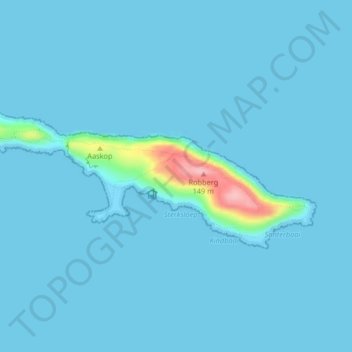
Name: Robberg Nature Reserve topographic map, elevation, terrain.
Average elevation: 7 m
Minimum elevation: 0 m
Maximum elevation: 140 m
Other topographic maps
Click on a map to view its topography, its elevation and its terrain.
Groot River
RSA > Western Cape > Bitou Local Municipality
Groot River, Bitou Local Municipality, Garden Route District Municipality, Western Cape, 6602, RSA
Average elevation: 253 m