
Thank you for supporting this site ❤️
Make a donation
Make a donation
Bontkirchen topographic map
Click on the map to display elevation.
Thank you for supporting this site ❤️
Make a donation
Make a donation
About this map
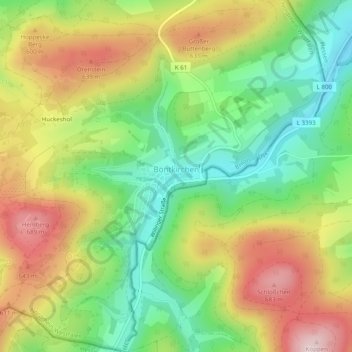
Name: Bontkirchen topographic map, elevation, terrain.
Average elevation: 526 m
Minimum elevation: 379 m
Maximum elevation: 709 m
Thank you for supporting this site ❤️
Make a donation
Make a donation
Other topographic maps
Click on a map to view its topography, its elevation and its terrain.
Poppenberg
Duitsland > Noordrijn-Westfalen > Hochsauerlandkreis > Brilon > Petersborn
Average elevation: 512 m