
Thank you for supporting this site ❤️
Make a donation
Make a donation
Burscheid topographic map
Click on the map to display elevation.
Thank you for supporting this site ❤️
Make a donation
Make a donation
About this map
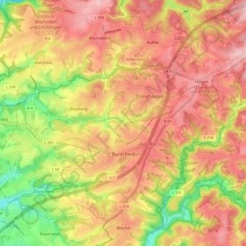
Name: Burscheid topographic map, elevation, terrain.
Average elevation: 182 m
Minimum elevation: 77 m
Maximum elevation: 252 m
Thank you for supporting this site ❤️
Make a donation
Make a donation
Other topographic maps
Click on a map to view its topography, its elevation and its terrain.
Bülsberg
Germany > North Rhine-Westphalia > Rheinisch-Bergischer Kreis > Odenthal > Altenberg
Average elevation: 164 m
Ketzbergerhöhe
Germany > North Rhine-Westphalia > Rheinisch-Bergischer Kreis > Wermelskirchen > Dabringhausen
Average elevation: 217 m
Hahnenberg
Germany > North Rhine-Westphalia > Rheinisch-Bergischer Kreis > Rösrath > Menzlingen
Average elevation: 123 m
Thank you for supporting this site ❤️
Make a donation
Make a donation